posted
Thanks for the encouragement Tex, Bdgee. This thread doesn't seem to generate much interest, and rightly so considering the type of forum I chose to post it in, but it is good to know that while comments are few, there are some who are silently following along...
My work is probably more appropriate for an Archeology or History forum, but I consider Allstocks my Internet home and I wouldn't feel right posting it anywhere else. (Sorry Bdgee... I'm here till they kick me out )
-------------------- One is never completely useless. One can always serve as a bad example.
IP: Logged |
posted
I went to my local library last week and checked out a few books that are frequently referenced in works regarding Andre Thevet. I have just finished reading one of them titled "Andre Thevet's North America" by Roger Schlesinger and Arthur P. Stabler. The first few chapters are on Thevet's life and works, written by the authors. The rest of the book consists of English translations of three of Andre Thevet's major books, "Les Singularitez de la France antarctique" (1556), "La Cosmographie universelle" (1575), and a portion of his unpublished book "Grand Insulaire" (1586).
One thing is quite clear after reading the book...
Andre Thevet was both a plagiarist and borderline senile in his later years. Some portions of his works, (particularly his last unpublished one, "Grand Insulaire"), are simply the same stories, rephrased and repeated over and over again and other paragraphs are blatantly copied word for word from previously published works by other authors. Ironically, Thevet was a very poor translator, and errors he made while plagiarising, often left him making ridiculous statements such as his translation of a native American phrase to mean "let's wash our beards" when the proper translation was "let's go to our boats". He also devotes large portions to refute works written by other authors, (two former employees in particular who have been subsequently proven more correct), claiming he is the utmost authority on whatever particular subject he is discussing. For example, he claims earthquakes are caused by bottled up winds inside the earth. He can also be proven a liar because he claims he was in three different places at the same time.
However, Thevet cannot be totally discredited, and some information included in his works appear to be original, including the first description of snowshoes, tobacco smoking and three unique "Native Canadian" names which can be found in no other works available to him at the time. And, while some of his works are stolen, he has done the world a favor by inadvertently preserving copies of other works, which would otherwise be lost to modern scholars. He was one of the most traveled Frenchmen of his time and had visited Italy, Switzerland, Naples, Venice, Levant, Rhodes, Athens, Alexandria, Lebanon, Arabia, Malta and Brazil all before his death in 1592. (Thevet claims to have visited Florida and Canada, but much evidence suggests he merely passed along the coast of those regions on his return trip from Brazil.) He held the office of royal cosmographer of France for four consecutive kings starting with King Henry II. He was good friends with the famous French explorer Jacques Cartier, (who had extensively explored Canada and surrounding regions), and other 16th century French "notables" such as Sebastian Cabot and Sieur de Roberval.
My interest in Thevet centers around his 1575 map that features a lake at the same latitude and longitude of the Great Salt Lake in modern day Utah. This map was published with his 1575 book "La Cosmographie universelle". It is based on Gerardus Mercator's 1569 map, which does not feature the above mentioned lake. Another 1575 map, published by Francois Belleforest, (Thevet's former employee), was featured in his published work (also titled "La Cosmographie universelle") but does not feature the lake either. This leads me to believe that the knowledge of this lake is unique to Thevet, or a source Thevet used which was not available to other authors at the time, (or even to his employees, as demonstrated by the Belleforest map). Thevet describes the "Cibola" and "Quivera" regions twice in his book, (common names given to the regions surrounding the lake), and even mentions the three main branches of the Colorado and confirms that they drain into the Gulf of California. No mention of a lake near either region is made, although Thevet does give the latitude of both regions, 35N and 40N, respectively.
I have learned that Thevet's primary source for his descriptions of "New Spain" and surrounding regions came from both his access to the "Mendoza Codex" and the works of other early explorers of the American Southwest such as Marcos de Nizza, Cabeza de Vaca, Coronado and Diego de Alcaraz. All these names should be familiar to anyone following my work, and all could theoretically be the source of Thevet's lake. However, I have done fairly extensive research on these explorers, and thus far found that none of them mention a lake to the north of "Cibola". This fact fits nicely with the idea that knowledge of the lake was exclusive to Thevet, for were it commonly known from one of the above mentioned explorers, the lake would be present in most maps of the period, starting around 1540 onward, which it is not. I have also found partial English translations of the "Mendoza Codex" and discovered that while this is indeed Thevet's main source for information on the Aztecs, thus far, it makes no mention of "Aztlan" or "Cibola", the supposed homeland of the Aztecs. According to modern scholars, knowledge of "Aztlan" comes primarily from both the "Botunrini Codex" and the "Florentine Codex", codices that Thevet likely had no access to. This leaves the source for Thevet's lake still unknown to me, but does provide some new avenues of research, and I am by no means finished researching...
Stay tuned, more to follow...
NR.
-------------------- One is never completely useless. One can always serve as a bad example.
IP: Logged |
posted
Hmmm, must have missed this before... There is an interesting comment by Thevet and a related footnote by the authors in the above mentioned book...
quote:"It is astounding the superstitions into which this poor people was plunged before the sun of the Gospel had shown forth over their country. I have in my possession two books* about the idols writ by hand containing the genealogy and history of the kings and great lords of that country, and the pictures of the idols they adored, painted and pictured in two books, written by hand by a monk who lived there around thirty-four years, exercising the charge of a bishop in that country. These books came into my hands* after having been presented to the late Queen of Spain, daughter of King Henry II, King of France. (5)"
quote:"(5) Thevet is here referring to his possession of the Codex Mendoza and possibly of the "Histoyre de Mechique". This story of the acquisition of the books, however, is different from that given in the Cosmographie, chap. 17: "On the Customs of the Country of the Mexicans," and is almost certainly a fabrication, as the document never reached Spain. The Queen of Spain to whom Thevet refers in Elizabeth of Valois, third wife of Philip II."
(*Bold is my addition)
If you will recall, the "Mendoza Codex" indeed never made it to Spain. It fell into the hands of the French while being shipped overseas from the "New World" to Spain, once again suggesting that Thevet was often less than truthful. (On the other hand, perhaps he is refering to how he came into possession of the "Histoyre de Mechique" rather than the "Mendoza Codex"?) I have done fairly thorough research on the "Mendoza Codex" and have found no references to a lake near "Cibola", however, I while I have heard of the "Histoyre de Mechique" during my studying, I have done virtually no research on it. Considering that this could be the source of Thevet's lake, it will be the subject of my studies for the next week or so.
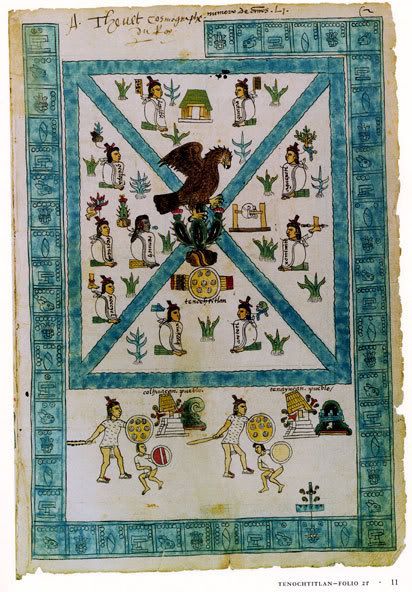
(Image of the first page of the "Mendoza Codex" featuring Thevet's signature. For educational purposes only.)
-------------------- One is never completely useless. One can always serve as a bad example.
IP: Logged |
posted
Uggg. I dunno Bdgee... First off, I am by no means finished with my research, and I don't feel like I am prepared enough to give a "conference" of any kind. In addition, I doubt there would be much interest in such topics in this area.. Hell, I've been in this area of PA for 5 years and I already know more about the local history here than probably 90% of the people that live here. If they have no interest in their own history, I doubt they would have any interest in the history of the Great Salt Lake.
I am having fun tho... LOL... I'm a nerd, what can I say?
-------------------- One is never completely useless. One can always serve as a bad example.
IP: Logged |
posted
Well, nerdy one, I suspect you will never find a place or time that many Joe Averages will show interest in your efforts. They are not prepared to appreciate the information or interpretations of it. That's not a put down for them. At least some of them could pin down just about any historian on the mechanisms of torque converters and some others on ornamental horticulture or computer languages. But I wasn't intending to suggest that you consider a presentation to a room full of them. I mean a conference of working historians.
You are getting fascinating and maybe new interpretations of things that may be of significance for actual historians. It's good work, dammit! Good enough to intereat the pros..
IP: Logged |
~1120 AD: The Mexicas, or Aztecs, leave Aztlan and wander south, in search of a new home. Aztlan is thought to have been a city built on an island in a large inland lake. Aztlan in native Nahuatl means "Place of Whiteness" or "Place of Egrets".
~1132 AD: Radiocarbon date for the last log cut and used at the famous Anasazi Pueblo, Chaco Canyon.
~1325 AD: The Mexicas arrive in Teonochitlan (Mexico City). Being the last of the clan to leave Aztlan, they are forced to build their homes along the shores of ancient salt Lake Texocco, for much of the valley the lake lies in is already occupied. They found the city of Teonochitlan on a small island in the center of the lake, and spend the next 200 years conquering and subjugating their neighbours.
1521 AD: Hernan Cortez conquers the Aztecs and captures the city of Teonochitlan. Before his death, Montezumma tells Cortez of Aztlan and it's supposed wealth. Montezumma suggests that Aztlan is "far to the north". Finding this legendary city will become the "MO" of almost every expedition undertaken by other Conquistadors of the period, who strive to gain the same fame and wealth that Cortez achieved through his conquests of the Aztec.
1536 AD: Cabezza de Vaca and a black slave named "Estevan" arrive in Mexico City. Their ship, part of a 1528 Spanish expedition to colonize Florida, was sunk during a squall. They spent a total of six years wandering the "New World". Both Cabezza de Vaca and "Estevan" tell of a large city named Cibola, and of it's fabulous wealth. Cibola in Spanish means "Buffalo" and is generally assumed to be located near the modern city of Zuni, NM.
1540 AD: Intrigued by De Vaca's stories, Viceroy of New Spain, Antonio de Mendoza authorizes a small expedition headed by the Franciscan friar Marcos de Nizza to confirm De Vaca's stories. De Nizza almost makes it to Cibola, but turns back and returns to Mexico City when Estevan, who had accompanied De Nizza as a guide, is killed by "citizens" of Cibola.
1542 AD: Coronado explores the American Southwest during his famous expedition. He arrives at Cibola, and finding no wealth, brands Cabezza de Vaca as a liar. A side expedition of Coronado's army, headed by Don Pedro de Tovar moves northwest, almost to the Utah border only to be stopped by the Grand Canyon. Tovar rejoins Coronado in Cibola and they proceed to the east. It is generally thought that they made it as far as modern day Missouri, a region subsequently named "Quivera".
1553 AD: The "Codex Mendoza" falls into the hands French Royal Cosmographer, Andre Thevet.
1565 AD: Francisco de Ibarra is granted authority by King Phillip II of Spain to conquer and administrate the region known as "Quivera". He is also searching of a city named Copala which lies on the shores of a large inland lake, surrounded by "Copal Trees", which he states is the "origin of the Aztecs". Don Pedro de Tovar, (of the Coronado expedition), hears of Ibarra's expedition and rushes out to join him. They are unsuccessful in finding the city of Copala or Lake Copala, but they do discover several silver mines in the Sierra Madres Mountains of Mexico, and Ibarra is generally credited with establishing the Mexican Provence of Durango, along with several of it's major cities. "Copal" in native Nahuatl means "Resin".
1575 AD: Francisco de Ibarra dies.
1575 AD: Andre Thevet publishes his book "La Cosmographie universelle" along with a world map. This map features a large lake at precisely the same latitude and longitude of the Great Salt Lake. This lake is featured in several other maps over the next 150 years before it disappears altogether until after the official discovery of the Great Salt Lake during the expedition of Dominguez and Escalante in 1776. Thevet claims his source of knowledge of the new world is mostly based on two books that he received as a gift from Elizabeth of Valois, third wife of King Philip II of Spain.
1581 AD: Inspired by stories of large Indian settlements waiting to be "converted" and authorized by the Spanish Viceroy, Fray Agustin Rodriguez, a Franciscan priest, lead a missionary expedition to the "Nueva Mexico" region. Rodriguez is ccompanied by Fray Juan de Santa Maria, Fray Francisco Lopez, nine soldiers, and nineteen Indian servants. They explore upper Texas and western New Mexico, but are forced to return when Fray Santa Maria is killed by natives, shortly after arriving at the city of Cibola. Despite the hostile environment, Fray Agustin Rodriguez and Fray Francisco Lopez remain behind, while the rest of the party returns to Mexico City.
1582: Antonio de Espejo sets out on an "unauthorized" rescue mission for the two friars left behind during the Rodriguez expedition. When Espejo arrives in Cibola, he learns that both friars have been killed. While there, he also learns from three natives that claimed to have accompanied Coronado's 1542 expedition that precious metals and more settlements could be found to the northwest, near the shores of a large lake. Espejo asserts in his official accounts of his expedition that this is the same lake that "Don Pedro de Tovar" set out in search for, although he does not specify if this was during the expedition with Coronado or the expedition with Ibarra. Espejo suggests that his rescue party should look into this further, but is "outvoted" and they eventually return to Mexico.
-------------------------------------------------
This is just a rough outline with the major events up to 1600 AD that I have identified as relevant to my research. Obviously much work is needed such as a post 1600 timeline up until the "offical" discovery of the Great Salt Lake, and minor events need added as well, but I'll leave that for another day.
My current focus is on "Copala" and "Lake Copala", which I believe is the lake featured on Thevet's 1575 map. Currently, I am trying to get access to an article that was in the October 1952 issue of "Utah Historical Quarterly" titled "The Myth of Lake Copala and the lands of Gran Teyago" by Lyman S. Tyler.
I am also interested in discovering why there are three different names for the "birthplace" of the Aztecs. The exact reason for the transition from Aztlan to Cibola to Copala is a bit of a mystery, however, I do have a few ideas on this subject, of which I will divulge after further research.
Finally, I feel I need to find a more concrete "informational" connection between 16th century Spanish explorers, (particularly Francisco de Ibarra), and the Frenchman Andre Thevet. Any connection between Thevet and King Phillip II of Spain is of particular interest as well.
Hope you enjoy my timeline, cause I enjoyed making it...
NR.
-------------------- One is never completely useless. One can always serve as a bad example.
IP: Logged |
posted
I recently finished reading "The Mapping of New Spain, Indigenous Cartography and the Maps of the Relaciones Geograficas" by Barbara E. Mundy. It was a worthwhile read, and has given me great insight into one of the "mysteries" I have run across during my research.
The book seemed to focus primarily on the stylistic differences between Indigenous and European Cartography. The Author uses responses to the "Relaciones Geograficas"*, a questionaire created by royal cosmographer Alonoso de Santa Cruz that was sent to dozens of "officials" in "New Spain" around 1575, with the intent of creating an accurate map of the "New World" for the King of Spain, Phillip II.
Indeed, while there were over 191 responses to the 50+ point questionnaire, the author draws attention to the fact that despite the seeming healthy response from the people in the "New World", the project in the end was a failure because of the vast differences between Indigenous and European visions of what a "map" should be.
To the European, a map was to "scale". This enabled a distance between any two points on the map to be calculated. In addition, every point on that map was "fixed" on a classic "Ptolemaic" grid using latitude and longitude. This allowed a course between any two given points to be calculated. Place names given on most European maps were typically the largest cities in a particular region.
Indigenous maps were neither to "scale" nor "fixed" to any grid. Indeed, while "scale" is present in some Indigenous maps, it is only in the form that one would find in a painting, where objects are drawn smaller when they are further away. In addition, place names were given based on the region and what you find in that region, not necessarily the largest "city" in that region.
Since a majority of the maps sent as a response to the questionnaire were drawn by natives and not Spanish officials, they were useless to Alonoso de Santa Cruz because they did not conform to the European "Ptolemaic" view of map.
However, this has provided insight for me because it explains why the "Homeland of the Aztecs" seems to have been given three different names. If we examine the meaning behind those three names, and view them from an Indigenous mind rather than a European one, a description of a "region" begins to emerge that, IMO, is not all that different from how one would describe the "pre-modern" Utah Valley. Also, consider what a typical Indigenous response to the Spanish question, "What is over there?" would be.
Azatlan: Place of Egrets, Place of Whiteness. Cibola: Buffalo Copala: Place of Copal or Copal Trees. (Pine Copal?)
I have also learned that the direction "North" was commonly associated with "Incense" in the Aztec world, though this was through a separate source, and I am still following this "lead"...
Also, a little something for anyone to "chew on"...
A few of the maps that were sent as responses to the questionnaire were more like "story maps" that showed a particular journey by an important person. In order to show the path of that person on the "map" they used footprints. The link below is NOT one of those maps, but it does feature the "footprints" common among a few of the maps included in the above book, which can be found in the link at the end of the second paragraph.
=) I'll be on this case til it's solved or I pass away...
I'm seriously trying to focus just on Thevet and Lake Copala, but the evidence keeps pointing to a bigger picture than just when the Europeans "discovered" the Great Salt Lake. I thought I'd throw it out there for discussion since "myth" seems to generate more excitement that cold hard historical facts
-------------------- One is never completely useless. One can always serve as a bad example.
IP: Logged |
posted
I found an intersting reference on an old map recently. The map was made by Alexander von Humboldt and published in 1804, much later than Andre Thevet's map.
I cannot completely read the text in the upper right corner of the map which features the "Great Salt Lake", however it appears to read:
quote:This Lake the (borders?) of which are very (imperfectly?) known from the Journals of Father Escalante is perhaps the Teyago Lake from the borders of which, according to some Historians, the (Azteques?) ??????? to the River Gila*.
*(Modern Day Colorado River)
I will post a link with a better image and corrected text if I can find it for anyone that might be interested. While this evidence is purely conjecture by the map's author, it is interesting never the less because it is one of several references to an Aztec connection to the Grand Teyago, or Great Salt Lake that I have found during my research. It is also interesting to note that while it could be pure coincidence or a result of mistaken identity, some "Cliff Dwellings" in the Southwest are known even today by Aztec names.
posted
Update for those who are interested (Bdgee?):
I am still trying to get my hands on a copy of a book by Francisco Ibarra's scribe, Bathlazar Obregon. Until I can obtain one, my research into the primary source for Frenchman Andre Thevet's 1575 map seems to be at a stand-still.
However, my work on this project as a whole has not stopped, it has mearly moved in a different direction. I have spend the bulk of my time organizing material and making sure existing references for that material were complete and accurate. In addition, two family members have offered to help me with both the writing and editing portion and one has even offered to help with the publishing process should my "project" ever reach that stage. This person has published their own book before, so I am confident that should I ever reach that bridge, I will have plenty of help crossing it.
I have also spent some time researching historic events that relate to the GSL and surrounding regions, but took place after the offical discovery of the GSL in 1776 by the "Domengiuez and Escalante expedition. In the past I have devoted little attention to this portion of the GSL's history because I am interested in the source of Andre Thevet's 1575 map, which I believe represents an unwritten chapter in the history of the European exploration of the American South-West.
As mentioned earlier in this thread, during all of my research on the "Pre-Discovery" (1500-1776) history of the GSL, I found several "official" connections between the natives of the American South-West, and the Aztecs of Mesoamerica. For example, a connection between the Aztec language Nahuatl and the Ute Indian native language has been so well establish that the both are included in what is called the "Uto-Aztecan Languages" group. It is also a well known fact that a major trade route existed between the natives of the American South-West and the Aztecs, and recent studies link Turquoise gemstones found in Aztec artifacts to sites in New Mexico and Nevada. In addition, objects such as Macaw feathers have been found at sites in New Mexico such as Chaco Canyon and Mesa Verde which date back to the early 1300's AD.
While the discoveries above have been made by others, I too have found some additional "circumstantial" evidences of a connection between the two. These have been outlined in previous posts in this thread, so I won't repeat them here.
Recent research into the "Post-Discovery" time period has revealed some pretty interesting but highly speculative evidence about a possible connection between the Aztecs and the Utes of Utah. While I will not get to much into the specifics because this evidence is still in the process of being verified, I will include links below to two of what I find to be the most interesting pieces of evidence and include a quick summary of my thoughts on each:
What I find the most interesting about the Freddie Crystal story is the location of Kanab, Utah. This town lies along a route that natives would have taken to cross the Grand Canyon, a route which the Spanish were unaware of, and one that the natives would not have shared with the Spanish, especially if it were the "escape route" for Montezuma's treasure...
When the Mormons arrived at the Great Salt Lake in the mid 1800's they were penniless. Within 3-4 years they were minting their own gold coins. Where did this vast wealth come from? If you ask the Mormans they will tell you it came from Mormon expeditions to California during the 1849 gold rush, and from the Rhodes Mines in the Unitas Mountians of Utah, the location of which is unknown to modern scholars. If one were to test the unique minerology of the gold coins minted by the Mormans, would it show the gold really came from South or Central America?
Also, here is a link to a webpage for someone who apparently has come to the same conclusion regarding the location of Aztlan as I have.
posted
The Story of Maps: Mesoamerica in North America By Roberto Rodriguez & Patrisia Gonzales
quote:Our investigation of historic and ancient maps of the continent began several years ago, when counselor/instructor Frank Gutierrez at East L.A. College passed on to us a small section of the 1847 Disturnell Map (1)). We initially did not ask him where he obtained it, though later, when we decided to investigate, he told us that a Hopi elder, Thomas Banyacya (2), had passed it on to him a generation ago at a gathering where native peoples were examining the importance of the Treaty of Guadalupe to native peoples of the continent. The map contained a type-written note on the map highlighting two sites. One notes that the "Moquis (Hopi) have been independent since 1680." (3) The other one points to the "Antigua Residencia de los Aztecas" or ancient homeland/residence of the Aztecs -- located north of the Hopi. (4) The map intimated -- in a typewritten note -- that this location was in Arizona.
There is much history regarding both these citations, the history of that map and the events of that gathering. For here, suffice to say that it led us on a journey, initially, simply to find out why an 1847 map maker would place such information on that map. This led us to begin to look for and eventually find older maps, chronicles and codices with the same or similar information.(5) Many people assumed that we were looking for Aztlan, "the legendary home of the Aztecs," (6) though truthfully, we were not. What we were intent on doing is a research investigation, thus, we could not begin with a conclusion. What we were simply and initially looking for was an explanation as to why the Aztec notation appeared on the map. In reality, there are three notations on the map that allude to a southward migration. (7) This search, which took us to many of the sites on these maps, actually led us to a broader origins/migrations search of Uto-Azteca or Uto-Nahuatl peoples. (8) It later even included a broader origins/migrations search (connections) of peoples from Canada, the United States, Mexico and Central and South America -- from Alaska to Chile.
...
quote:* Many explorers/chroniclers who lived or passed through present-day northern Mexico or the present-day U.S. Southwest were pointed northwards toward a lake as the point of origin of many Nahuatl-speaking peoples. The lake that shows up in many of the early maps, as the point of origin appears to be Salt Lake. (The 1804 Humboldt Map, The 1768 Alzate Map & The 1729 Barreiro Map all point to what is today Salt Lake -- or possibly Utah Lake). Most codices (Tira de Peregrinacion, Codex Aubin) appear to depict an island within a lake. Historically, this lake has been known by various names, including Copala, Teguayo, Timpanogo and several others. (Most codices also depict a migration coming from seven caves -- interpreted by many to signify seven nations or lineages.)
It's pretty clear that Roberto Rodriguez & Patrisia Gonzales are primarily interested in the origins of the Aztec people, and that they believe it to be somewhere in the modern US. As you can see from previous work on this thread, I have come to a similar conclusion myself during the course of my own research. But, as mentioned before, this is not the primary goal of my research.
What caught my attention, is that they mention the GSL several times, and suggest that it can be found on several maps dating back to possibly 1536-66.
quote:1536 Santa Cruz. Cites Nuevo Mexico near a lake, that may be Salt Lake, though it is depicted in an area closer to the Great Lakes. Dennis Reinhartz cites as possibly 1566, though even that date would make it the earliest citation for the name of Nuevo Mexico.
Currently, the oldest map I have found featuring the GSL is the Andre Thevet map of 1575. I am currently trying to find an image of the 1536/66 Santa Cruz map mentioned to verify that it indeed shows the GSL, though based on what I have seen on previous maps the lake they mention is probably "Lake Conibaz", which I am fairly certain does not represent the GSL.
However, if they are correct in their interpretation of the 1536/66 map, this could help my research greatly because I am still having trouble finding the source for Andre Thevet's 1575 map because he was a known plagiarist. Finding an older map featuring the GLS made by someone other than Thevet could greatly increase the credibility of my theory and also open new avenues of research.
Finally, what I find most interesting about their work is that even though Roberto Rodriguez & Patrisia Gonzales apparently studied dozens of maps from the 17th-19th centuries, and mention the GSL as possibly being featured in maps as early as 1536, they make no attempt to explain why the GSL would be featured on maps prior to it's official discovery in 1776. Perhaps this is because the discovery date of the GSL was not their primary research goal, but one would think that someone knowledgeable in the history of the American Southwest, (as Roberto Rodriguez & Patrisia Gonzales appear to be), would be intrigued at the prospect of the GSL being shown on maps dated prior to it's official discovery, just as I was when I first saw the 1610 Henry Briggs map featured on the first page of this thread.
NR.
-------------------- One is never completely useless. One can always serve as a bad example.
IP: Logged |
posted
I have seen the show a few times before but they mostly focus on family/local folklore/legends or amazing historical stories behind seemingly ordinary household objects. I doubt they would be interested a theory about the discovery of the GSL.
-------------------- One is never completely useless. One can always serve as a bad example.
IP: Logged |
quote:Originally posted by NaturalResources: I have seen the show a few times before but they mostly focus on family/local folklore/legends or amazing historical stories behind seemingly ordinary household objects. I doubt they would be interested a theory about the discovery of the GSL.
can't bleeve you'd diss me like dat...
ok, try natgeo, then.\
But try, whatever.
Ya ta hey
-------------------- Nashoba Holba Chepulechi Adventures in microcapitalism...
IP: Logged |
posted
Ugg, wasn't trying to diss you. (I don't want to diss anyone who posts in this thread.) Sorry if it came across that way. I'll take your advice and shoot an email their way. My ideas might not make an ideal episode of "History Detectives" but I bet they could help point me in the right direction. Thanks Tex.
NR.
-------------------- One is never completely useless. One can always serve as a bad example.
IP: Logged |
posted
Curious if anyone has ever heard of the "Peralta Stone Tablets"? This article is over 3 years old, and since I haven't heard anything recently about discoveries of Aztec Treasure in Utah, I assume nothing ever came of it, (other than a few DVD sales).
Ancient Native American Discoveries & Spanish Artifacts Unearthed In Utah
I've translated this through Google and a couple other free online translators but all of them are having trouble providing a full translation... Perhaps because it is 16th century Spanish?
quote: hallo un indio en aquellos llanos quien lo dijo, mas por senas que por voces, ser de una provincia que distaba treinta soles, la cual se llamaba Copala, y al indio se le puso por nombre el turco, por ser muy moreno, apersonado y de buena disposicion; y les dijo tantas cosas de aquella provincia, que los puso en admiracion, y en especial que habia tanta cantidad de oro, que no solo podian cargar los caballos, sino carros ; que habia una laguna en la que navegaban canoas, y que las del casique tenian argollas de oro; y para que se esplicase, le mostraban plata, y decia que no, sino como un anillo que vio de oro: decia que a su casique lo sacaban en andas a las guerras, y que cuando queria, los quitaban los bosales a unos lebreles que despedazan a los enemigos ; que tenian una casa muy grande, a donde todos acudian a servirle; que en las puertas tenian mantas de algodon
-------------------- One is never completely useless. One can always serve as a bad example.
IP: Logged |
posted
Took your advice Tex, asked around, and co-worker put me in touch with someone they know who is working for their BA in Latin American Studies at Penn State. This person provided me with a rough translation, (very similar to the Bablefish translation BTW), and promised to email me a more accurate version. This person also told me I could contact them in the future if I thought they could be of any more help. In the mean time, here is what is so exciting about this reference I have found, (even though this new evidence is forcing me to review and revise portions of my work that are already "completed".)
From Pedro Castañeda's 1554 account of the Coronado expedition, (with rough translation in italics below):
quote:ser de una provincia que distaba treinta soles, la cual se llamaba Copala
that 30 days travel was a province named Copala
quote:que habia una laguna en la que navegaban canoas, y que las del casique tenian argollas de oro
"they have a lagoon they sail canoes on, that they wear earings of gold"
I missed this before because I searched for a "lake" among accounts of Coronado's expedition, not a "lagoon".
Further investigation reveals that this quote was attributed to an indian named "The Turk", who was intrumental in leading Coronado's expedition to failure on the plains of the midwest. (For some reason the accounts state "The Turk" was leading them to "Quivera", not "Copala".)
P.S. I also emailed "History Detectives" last week, per your suggestion but I haven't recieved an email back yet. I'll post the response here if I get one. NR.
-------------------- One is never completely useless. One can always serve as a bad example.
IP: Logged |
posted
I never did get a response from History Detectives, in case anyone was still interested... I shelved this project in May due to frustration and personal obligations but things have settled down lately, and I think I finally have the time to dust this thing off and get back to work on it.
-------------------- One is never completely useless. One can always serve as a bad example.
IP: Logged |
"The Codex Mendoza was hurriedly created in Mexico City, to be sent by ship to Spain. The fleet was attacked by French privateers, and the codex, along with the rest of the booty, taken to France. There it came into the possession of André Thévet, cosmographer to King Henry II of France. Thévet wrote his name in five places on the codex, twice with the date 1553. It was later bought by the Englishman Richard Hakluyt for 20 French francs. Some time after 1616 it was passed to Samuel Purchase, then to his son, and then to John Selden."
Both Richard Hakluyt and Samuel Purchase published maps showing a lake at the same Lat./Lon. as Thevet, AFTER they obtained the "Codex Mendoza".
I'm still following this one out, but if I can find maps from Hakluyt and Purchase that PRE-DATE their acquisition of the "Codex Mendoza" and show that they do not have a lake, it might suggest that knowledge of said lake came from the "Codex Mendoza".
-------------------- One is never completely useless. One can always serve as a bad example.
IP: Logged |
price appears to be if you have to ask? you can't afford it...
what an amazingly accurate map for the date, huh?
It appears that the Brits got their info from the French, who in turn, had stolen it from the Spanish.
Englishman Richard Hakluyt purchased the "Codex Mendoza" from Frenchman Andre Thevet in 1587. The very same year, Hakluyt published a map which shows a lake in the same location as Thevet's 1575 map. This Codex was stolen from the Spanish by the French and landed in the hands of Thevet around 1553.
"At the age of 30, being acquainted with "the chiefest captaines at sea, the greatest merchants, and the best mariners of our nation",[11] he was selected as chaplain and secretary to accompany Stafford, now English ambassador at the French court, to Paris in 1583. In accordance with the instructions of Secretary Francis Walsingham, he occupied himself chiefly in collecting information of the Spanish and French movements, and "making diligent inquirie of such things as might yield any light unto our westerne discoverie in America"
Richard Hakluyt's purchase of the Codex from Thevet makes sense because it was a stolen Spanish document with information regarding the Americas. Hakluyt was simply performing his duties under the direction of "spymaster" Francis Walsingham.
Any information that Hakluyt learned would most likely have been passed on to Walsingham, which may explain how a lake shows up on the Dutch Jodocus Hondius map, (which you previously linked), also published in 1587.
The Dutch were allies with the English at the time and Jodocus Hondius is primarily known for publishing the works of Sir Francis Drake. IMO, it doesn't seem too far of a stretch to suggest that Jodocus Hondius,(because of his close connection with Drake), may have obtained information regarding a lake from either Walsingham or Hakluyt.
-------------------- One is never completely useless. One can always serve as a bad example.
IP: Logged |
posted
Here is another interesting lead which I must follow up on.
It is very similar to the Cabeza de Vaca story. It takes place around 1569. David Ingram, an Englishman, becomes shipwrecked in Mexico and ends up in being rescued in Nova Scotia some 11 months later.
Ingram's account was written down 13 years later in 1582 by Sir Francis Walsingham, (Ingram himself was illiterate), and subsequently published in 1589 by Richard Hakluyt.
It is generally believe to be fictional because Ingram claims to have seen Elephants during his journey, but also because the distance traveled was to great to have been accomplished in less than a year. (Cabeza de Vaca's journey, being a shorter distance, took place over the course of several years).
Regardless, since this Journey takes place before Thevet's 1575 map, and Ingram may have passed near the Southwest, I plan on looking into this further.
-------------------- One is never completely useless. One can always serve as a bad example.
IP: Logged |


 UBBFriend: Email this page to someone!
 Printer-friendly view of this topic


![[Big Grin]](biggrin.gif) )
)
![[Cool]](cool.gif)
![[BadOne]](graemlins/headbash.gif)
![[Razz]](tongue.gif)
![[Wink]](wink.gif)


