I am currently doing some personal research on the Great Salt Lake in Utah.
According to all current "official" accounts that I can find, the Great Salt Lake was not known to the "white man" until around 1776 when Spanish missionary explorers Dominguez and Escalante learned of Great Salt Lake from the Native Americans.
Also according to all current "official" accounts, the first white person known to have visited the lake was Jim Bridger in 1825.
However, I believe I have found evidence that proves Dominguez and Escalante were NOT the first "white men" to learn about and document the existence of the Great Salt Lake.
After 4 weeks of exhaustive research on the Internet I have come to the conclusion that I may be the first to realize this evidence for what it is; proof that the "white man" knew about the Great Salt Lake in the late 1500's to early 1600's.
Due to the fact that I believe my compelling evidence, (while not proof positive), has been overlooked until now, I will not be revealing this evidence until I can do further research and find a way to make sure I am given credit, should my theory prove true.
Currently, I am looking for ANY and ALL information, websites, books, etc. that relate to "official" information regarding the discovery of the Great Salt Lake.
I am also looking for information on the following Spanish Missionaries and Explorers or anything related to their expeditions of the southwestern US in the late 16th - early 17th centuries:
1) Fray Marcos De Nizza (De Niza or De Nisa according to some spellings) 2) Cabeza de Vaca 3) Diego de Alcaraz 4) Francisco Vasquez de Coronado 5) Pedro de Castañeda 6) Antonio de Espejo 7) Francisco Sánchez Xamuscado (Chamuscado according to some spellings)
I am asking anyone at Allstocks to please post any relevant information or links on this thread. Anyone who posts information that furthers my research will be given credit, should my theory pan out.
I will reveal my evidence at a later undetermined date, unless someone knows a way I can assure that someone else won't run off with my theory without giving me credit, should I post the evidence here in a public forum.
If anyone knows how I could accomplish this so that I can post the evidence immediately in order to facilitate quicker and more thorough research, please by all means let me know either via this thread or via PM.
TIA, NR.
Posted by Pagan on :
quote:Originally posted by NaturalResources: I am currently doing some personal research on the Great Salt Lake in Utah.
According to all current "official" accounts that I can find, the Great Salt Lake was not known to the "white man" until around 1776 when Spanish missionary explorers Dominguez and Escalante learned of Great Salt Lake from the Native Americans.
Also according to all current "official" accounts, the first white person known to have visited the lake was Jim Bridger in 1825.
However, I believe I have found evidence that proves Dominguez and Escalante were NOT the first "white men" to learn about and document the existence of the Great Salt Lake.
After 4 weeks of exhaustive research on the Internet I have come to the conclusion that I may be the first to realize this evidence for what it is; proof that the "white man" knew about the Great Salt Lake in the late 1500's to early 1600's.
Due to the fact that I believe my compelling evidence, (while not proof positive), has been overlooked until now, I will not be revealing this evidence until I can do further research and find a way to make sure I am given credit, should my theory prove true.
Currently, I am looking for ANY and ALL information, websites, books, etc. that relate to "official" information regarding the discovery of the Great Salt Lake.
I am also looking for information on the following Spanish Missionaries and Explorers or anything related to their expeditions of the southwestern US in the late 16th - early 17th centuries:
1) Fray Marcos De Nizza (De Niza or De Nisa according to some spellings) 2) Cabeza de Vaca 3) Diego de Alcaraz 4) Francisco Vasquez de Coronado 5) Pedro de Castañeda 6) Antonio de Espejo 7) Francisco Sánchez Xamuscado (Chamuscado according to some spellings)
I am asking anyone at Allstocks to please post any relevant information or links on this thread. Anyone who posts information that furthers my research will be given credit, should my theory pan out.
I will reveal my evidence at a later undetermined date, unless someone knows a way I can assure that someone else won't run off with my theory without giving me credit, should I post the evidence here in a public forum.
If anyone knows how I could accomplish this so that I can post the evidence immediately in order to facilitate quicker and more thorough research, please by all means let me know either via this thread or via PM.
TIA, NR.
Ok, this might seem totally stupid. But what is your point?
Posted by NaturalResources on :
Not exactly sure what you mean, I thought it was pretty clear but...
I think the record books are wrong about who "discovered" the Great Salt Lake and when it was "discovered" and I think I have found evidence that proves it.
I want to reveal the evidence to the public for scrutiny without some professor somewhere reading it and then writing a paper about it taking full credit for himself.
I have no education beyond a few college courses and have no idea how to further this "theory" without say, having to write a book about it.
I guess I am looking for advice and maybe some help with research from someone who is maybe a bit more edumacated that I....
Posted by glassman on :
i assume you are looking prior to Eteinne Provost?
Posted by NaturalResources on :
Yes, much prior to Eteinne Provost (1824-1825). The evidence I have found dates to the early 1600's.
The only "white men" anywhere near the Great Salt Lake during that time period that could have learned of and documented it's existence were early Spanish missionaries and explorers, thus my interest in the names I originally posted.
Posted by glassman on :
Ok, if history is like science? you are going to find a peer-reviewed journal to present your paper to. they will review it and if they want to publish? they will (99% chance) ask you for a rewrite before they publish and if they don't want it? they'll just reject it.
there is still a risk of your ideas being stolen. there's not much monetary value to anybody but the people who would be selected to review it. to them, a publication is job security. since you aren't "in the business", it's almost impossible to protect your right to credit without "friends in the business"...
Directory of History Journals Welcome to the AHA's Directory of History Journals. This database provides helpful links to peer-reviewed English-language journals that publish in all fields of history. Just choose a subject category from the list below and the journal's description and submission information are a mouse-click away. Youve expended enough energy researching and writing your paper; let us help you find a place to publish it. No more time-consuming searches on the internet!
are there any historical societies that specifically focus on the lake or the region? you might be able to publish it in something they put out without peer review...
if you want credit, and are willing to spend some money? then self-publishing a short book is one way.
Posted by NaturalResources on :
Glass,
quote:Ok, if history is like science? you are going to find a peer-reviewed journal to present your paper to. they will review it and if they want to publish? they will (99% chance) ask you for a rewrite before they publish and if they don't want it? they'll just reject it.
I have a lot of work to do before I have anything that even resembles a paper that I could submit to a peer-reviewed journal. Most of my research is in the form of notes and short paragraphs, with a few time lines and maps, links, images, etc... This includes six main pieces of evidence that will make or break the theory...
quote:there is still a risk of your ideas being stolen. there's not much monetary value to anybody but the people who would be selected to review it. to them, a publication is job security. since you aren't "in the business", it's almost impossible to protect your right to credit without "friends in the business"...
I'm not doing this for monetary gain, just doing it out of my passion for history and to "set the record straight"... though in the end I wouldn't mind if credit was given where credit is due...
quote:Directory of History Journals
Welcome to the AHA's Directory of History Journals. This database provides helpful links to peer-reviewed English-language journals that publish in all fields of history. Just choose a subject category from the list below and the journal's description and submission information are a mouse-click away. Youve expended enough energy researching and writing your paper; let us help you find a place to publish it. No more time-consuming searches on the internet!
are there any historical societies that specifically focus on the lake or the region? you might be able to publish it in something they put out without peer review...
Again, I'm no where near having a paper I could submit, but I'll bookmark that link for later use. Also, I definitely should read up on anything put out by a regional historical society for the Great Salt Lake area, if one exists. It may be that I'm following in someone else's footsteps, and that information just hasn't made it to the mainstream media yet.
quote:if you want credit, and are willing to spend some money? then self-publishing a short book is one way.
Self publishing isn't really an option at this point in time due to financial reasons, even if I had something put together that could be published. However I do have a family member who has self published before so I will have help there if I ever reach that point.
Regardless... thanks for the reply Glass. I'm beginning to think maybe I should just reveal the evidence here and let you guys tear it apart before I go through the effort of putting together something worth publishing. For all I know, I may be completely overlooking the obvious and my theory is a total wash.
NR.
Posted by NaturalResources on :
Well... ...Here goes nothing. This is one of the major pieces of evidence I have uncovered.
This map was made by Henry Briggs, (February 1561-January 26, 1630), an English mathematician notable for changing Napier's logarithms into common/Briggesian logarithms.
It is dated 1625 AD and was one of the first maps to incorrectly show California as an island. This was an error that was copied to later maps all the way up until the early 1700's and created a dispute among cartographers that was not conclusively settled until the expeditions of Juan Bautista de Anza traveled between Sonora and the west coast of California in 1774-1776.
Take note however, of the large lake shown as the source of the Colorado river and the labled "town" just to the south of the lake in the Henry Briggs map. Close examination of larger replications of this map reveal that the "town" is labeled "Real De Neuvo Mexio" or "Road of New Mexico".
This, (coupled with much more evidence which I am currently withholding), IMO, means that it was a well known fact when the Henry Briggs map was published in 1625 that there was a large lake to the north of New Mexico, (the northern most regions reached by the well documented expedition of Francisco Vasquez de Coronado in 1540-1542), which could only be the Great Salt Lake.
Keeping in mind that according to all "official" accounts, the Great Salt Lake was not even known about by the "white man" until Juan Bautista de Anza's expeditions, do you guys think I am on to something or should I throw my theory into the trash heap and move on to other things?
TIA, NR.
Posted by bdgee on :
NR, never throw any idea into the trash unless you have found conclusive irrefutable evidence that it is indeed JUST trash.
Posted by glassman on :
can you find a source for his map?
here's another one from between Briggs map and Anza's expedition that show it:
Thanks for the encouragement, I just feel like I am overlooking the obvious. Many, many, people much more educated than I have probably poured over these maps for centuries, but never spotted the "Great Salt Lake" on them? Seems highly unlikely IMO... I'd hate to spend more time, effort and money on this "theory" only to realize I'm not the first to stumble across this or that there is a simple, already known explanation.
Glass,
I cannot find a source at the current time but as I stated in my original post, it must have been via Spanish explorers or missionaries in the late 1500's until the early 1600's because they were the only Europeans in the area at the time. For this reason, I suspect that Henry Briggs that the original source for Henry Brigg's map must have been either a Spanish map or report.
Thanks for the link. As far as I can tell with my research, the same lake is featured in many maps dating from 1598 until around 1725, shortly before it's "official" discovery via communication with Natives in the area during Bautista's expeditions.
Posted by glassman on :
heres' a British one for sale from 1587 (supposedly) that has it too.. (
i'm wondering how the Brits got the Spanish maps, there must be some connection...
i bet that if you can find the one the brits were copying from? you'll find who was there.
price appears to be if you have to ask? you can't afford it...
what an amazingly accurate map for the date, huh?
Posted by NaturalResources on :
Thanks again Glass, I didn't have that map in my evidence pile, and 1587 is the earliest map I've seen that shows the lake.
I'm thinking along the same lines as you, find the source for the map, and I've got a "smoking gun" so to speak. The problem is, there are several well known expeditions that were in the area early enough to be the source for these maps, but none of them have been proven to have made it further north on the west side of the Rockies than the Grand Canyon, which was reached via a small "side exedition" of Coronado's men conducted while Coronado's force rested after the Battle of Hawikuh at Cibola.
Cabeza de Vaca got lost on his trip from Tampa to Mexico... 1528-1536
mighta been him...
Traveling mostly in this small group, Cabeza de Vaca explored what is now the U.S. state of Texas, and possibly smaller portions of New Mexico and Arizona. Posted by NaturalResources on :
Cabeza de Vaca's account of his journey in 1528-1536 was the motivation behind both Fray Marcos De Nizza's 1539, and Francisco Vasquez de Coronado's 1542 expeditions seeking the legendary "Seven Cities of Cibola", rumored to be cities made of solid gold.
I have read through a translation of his account "La Relación" or "The Relation", and can find no mention of anything resembling a description of the Great Salt Lake or it's mention among conversation with the countless groups of natives he encountered during his 8 years of travel.
In addition, most historians agree that the furthest north reached by De Vaca was the small pueblo Hawikuh which was later conquered by Coronado, (in the previously mentioned "Battle of Hawikuh"), which is just to the south of modern Zuni, New Mexico.
However, his writings are vague and filled with large "time" gaps, some of which appear to be multi-month periods in which he wrote nothing of his journeys. I have read in a few places he later published a second, more detailed account of his journey, however the original was lost in a fire, and no known copies presently exist.
Posted by NaturalResources on :
Im curious Glass, what search terms are you using to find those maps?
Posted by glassman on :
early north american maps ... image function lets you scan quicker..
Posted by NaturalResources on :
Glass, you asked earlier how the Brits could have obtained copies of Spanish maps...
An interesting note that I ran across during my research:
During his 1577 expedition sponsored by Queen Elizabeth, Sir Francis Drake captured several Spanish ships in the Pacific off the coast of South America fill with treasure. It has been said that Drake used their more "accurate charts" during the rest of his journey north. It is highly possible that these charts could have been the original source for the Henry Briggs map of 1625.
Coincidentally, many of the charts used by Drake, and records of his expedition were lost when Whitehall Palace burned to the ground in 1698, which might explain why most maps made after the early 1700's do not show a large lake north of New Mexico.
Posted by glassman on :
that makes sense... Drake was a pirate with a license.
Posted by NaturalResources on :
Further details from a book titled "Pillaging the Empire" By Kris E. Lane.
On pages 45 and 46, in reference to Drakes capture of the treasure laden Spanish galleon Cacafuego:
quote:"Short of the substanital feat of circumnavigation this was as good as it would get for Drake. Another prize was taken off Cano Island (Costa Rica) by the crew's pinnace on 20 March 1579 while the Golden Hind was being careened.
As luck would have it, the small vessel, though carrying little of value in its hold, had aboard two pilots of the Manila galleon route. These men, Alonso Sanchez Colchero and Martin de Aquirre, just happened to have their chart-books, or derroteros, along with them. Only Sanchez Colchero was detained, the others having been let go to sail the pirates own pinnace back to Nicoya, whence they had come.
Posted by NaturalResources on :
Ok well, I have my smoking gun... I've got a name, date and proof of the source for the lake that shows up on maps starting in 1587.
I'm am confident my theory is sound, and I want to move to the next step of creating a paper to present my theory.
Do any of you know any tips or tricks for how to go about the process of writing a paper? At this point all I have is a jumble of loosely organized notes and I'm not exactly sure of how to organize that into something that can be published.
NR.
Posted by glassman on :
tips or tricks for how to go about the process of writing a paper?
Thanks Glass. A lot of work ahead of me, still working on sorting everything based on the format used in the link you posted. I've got a short thesis paragraph written out, and I'm hoping I'll be organized enough to write the introduction starting sometime next week, (I've got a busy work schedule this week).
Anyhow, thanks again for the help, and just so you know, that map you found from is still the oldest map I have as evidence that shows the "lake". Also the date, 1587, fits perfectly (within 5 years) with other collaborating evidence that I have.
When I reach the point of completion, your "name" will included as an assistant researcher.
NR.
Posted by glassman on :
cool. i hope it generates some interest...
Posted by glassman on :
BTW? it would be good to read a couple of other historical papers to get an idea how other people aproach the writing too...
find one you like and "reverse engineer" it by writing it's outline...
Posted by NaturalResources on :
Good idea Glass, Thx again.
I stayed up late last night and finished a rough outline based on the last link you sent me. I am having a problem however, with figuring out the order to present the evidence in the body of the "paper".
It seems to make the most sense to organize the body based on a timeline, because I am trying to show that maps before a certain date do not show the lake, then after a certain date the lake is shown in order to demonstrate that a certain expedition is responsible for the information used to create the maps where the lake is shown.
However, certain events relevant to the "discovery" of the lake take place before or after their proper location in the timeline based body suggests they should be revealed.
Am I approaching this wrong using a timeline based body, or am I approaching the purpose of the body wrong, and I should relay all information in a time-based linear fashion in the body with out making any connections with the evidence, and then use the Analytical Summary section in the paper to tie all the evidence in the body together?
Also, how do I use information I know to be true and correct that is often used for fringe or far fetched theories without the risk of being associated with such theories?
TIA, NR.
Posted by glassman on :
it sounds like you are now getting into the art of writing a paper.
it sounds (to me) like you need to try to find a paper that deals with the same sort of timeline issues to see how they handled it...
my history reading is almost entirely in historical based fiction like the Sharpe series by Bernard Cornwell
in general i would ASSUME that you would state your new theory in the intro and then relay all information in a time-based linear fashion in the body with out making any connections with the evidence, and then use the Analytical Summary section in the paper to tie all the evidence in the body together.
don't forget to make citations, "facts" are not accepted at face value...
Posted by NaturalResources on :
It has been a while since I've posted on this thread so I thought I might give an update in case any of you out there were interested.
While in the process of creating my paper to prove my theory, I realized I needed better quality images of some of the maps I am using as evidence so that certain features can easily be seen. As I was searching, I discovered another map that shows what I believe to be the Great Salt Lake.
This map is from 1575, which PRE-DATES the earliest map I had as evidence which is dated 1587, (This is the map found by Allstocks very own "Glassman"). Unfortunately, this map also PRE-DATES my other key piece of evidence, a written document by a Spanish priest from 1584 that claims natives of New Mexico told him of a "large lake to the north".
While this does not mean my theory is wrong, it does mean pages of typed text have to be trashed and hours of work have been wasted following false leads. It also means I have to go back to the drawing board and start from scratch in figuring out who could have been responsible for the information used to create the 16th century maps that appear to show the Great Salt Lake.
While I am a bit discouraged, I am still trudging forward on this and I'll post any major developments as they occur.
NR.
Posted by bdgee on :
Keep it up, NR.
The only true failure in scholarship is the failure of not trying.
You're already beyond where you were before you started and have even more data to study. You are already being a success.
Posted by Peaser on :
NR, Have you seen Ortelius oval world map of 1570, Gerard Mercator's in 1569, or Benedetto Bordone's in 1528?
old maps are cool. considering how they had to guess how far they had gone east and west it's pretty amazing how close they were.
there's another old map that still has afficionado's scratching their heads too.
In 1929, a group of historians found an amazing map drawn on a gazelle skin. Research showed that it was a genuine document drawn in 1513 by Piri Reis, a famous admiral of the Turkish fleet in the sixteenth century. His passion was cartography. His high rank within the Turkish navy allowed him to have a privileged access to the Imperial Library of Constantinople. The Turkish admiral admits in a series of notes on the map that he compiled and copied the data from a large number of source maps, some of which dated back to the fourth century BC or earlier.
The most puzzling however is not so much how Piri Reis managed to draw such an accurate map of the Antarctic region 300 years before it was discovered, but that the map shows the coastline under the ice. Geological evidence confirms that the latest date Queen Maud Land could have been charted in an ice-free state is 4000 BC.
the implication of the existence of the Piri Reis map is that we are missing a huge chunk of history.
Piri Reis used several different sources, collected here and there along his journeys. He himself has written notes on the map that give us a picture of the work he had been doing on the map. He says he had been not responsible for the original surveying and cartography. His role was merely that of a compiler who used a large number of source-maps. He says then that some of the source-maps had been drawn by contemporary sailors, while others were instead charts of great antiquity, dating back up to the 4th century BC or earlier.
the US Navy confirmed that the map was more accurate than their own in 1953, and that it used plane geometry, containing latitudes and longitudes at right angles in a modern grid, but it is obviously copied from an earlier map that was projected using spherical trigonometry, and that much of the map showed features under a mile of ice.
getting accurate longitudes was impossible until this:
The British Longitude Act of 1714, in the reign of Queen Anne, promised a prize of 20,000 english pounds for a solution to the longitude problem to anyone that could provide longitude to an accuracy of 1/2 degree. It was an immense amount of money at the time, the equivalent of millions of dollars today.
As Dava Sobel explains, "to know one's longitude at sea, one needs to know what time it is aboard ship and also the time at the home port or another place of known longitude-at that very same moment. The two clock times enable the navigator to convert the hour difference into geographical separation. By the time the Royal Commission was disbanded in 1828, it had paid out in excess of 100,000 pounds on determining a method of finding 'longitude', tax payers money for once well spent, British vessels were enabled to navigate the oceans of the world, first by lunar distance and then by ships chronometer, supporting the founding of an empire and a world power.
hmmmmmm.... there's that conundrum again, "tax payers money for once well spent"
Posted by Peaser on :
Life was so much more simplified then...
They didn't think so though.
Jeb dun got da fever. Goodnight Irene...
Posted by NaturalResources on :
Bdgee,
Thanks for the continued encouragement. This is becoming a much larger project than I first anticipated, but the thrill of discovery drives me forward.
...
Peaser,
I have seen all of the maps you linked above with exception of the third you mentioned, the Benedetto Bordone map of 1528. This is because I have excluded researching maps that show only the exterior shores of the North American continent or maps that are dated prior to 1539.
Since I am looking for information that was gained via inland exploration, (discovery of the Great Salt Lake), I believe I can exclude most maps that only feature the shores because the information they contain has mostly been gathered by ships sailing along the coast. In addition, the earliest documented exploration in North America anywhere close to the Great Salt Lake did not take place until Cabeza de Vaca's journey in 1539, so I am fairly certain I can exclude any map dated prior to 1539.
(My original intent was to document every 16th century North American map available and compare different features to show conclusively that maps before a certain date do not show the GSL and maps after a certain date show the GLS, however this has proven both time consuming and unnecessary. Ironically, the very same book you linked to was instrumental in allowing me to focus my research on 20-30 different maps instead of hundreds of maps. It is also a book which I intend on adding to my personal library.)
The two other maps you linked both show large lakes in the interior of the North American continent. However, there is certain other critical evidence which I am withholding at the current time which leads me to decisively conclude they are not a representation of the Great Salt Lake. (Note that the shores of the large lake on the 1569 Mercator map touch the arctic circle.)
...
Glassman,
I have always had a fascination with maps, especially old ones. This is probably what led me to pursue a career in Surveying.
I have read a bit here and there about the Piri Reis map. IMO, there are compelling arguments both for and against whether or not the map is authentic. I think knowledge of Antarctic features in the Piri Reis is one of the most compelling arguments towards it's authenticity.
If it is authentic, I do agree that we are missing a large chunk of our history, which would not surprise me considering such archival atrocities as the burning of the Library of Alexandria, or destruction of Incan Quipu by the Spanish Conquistadors.
I would only add that while determining longitude AT SEA was very difficult until the mid-1800's, in the 16th century it was quite EASY to determine one's longitude ON LAND, (once you reached it), with only an astronomical table and a few days, (and nights), of careful observations.
....
In closing, I would like to thank everyone for their comments, and I look forward to further exchanges.
NR.
Posted by Peaser on :
(Note that the shores of the large lake on the 1569 Mercator map touch the arctic circle.)
Yes, but what about the lake that is southwest of the lake that you are speaking of? Unless I am mistaken and the article circle represents the circumference of the map.
My bad, I was looking at his 1589 map.
Posted by Peaser on :
Yeah g, I spent a couple hours checking out old maps the other night.
It's pretty amazing what folks were able to do back in the day.
Posted by bdgee on :
"...but the thrill of discovery drives me forward."
I knew that would happen, because I have been there before and have been there when it has taken over others. Like one of them said, "This is better than sex" (of course I type "sex", though that was not the word he used....) .
Posted by NaturalResources on :
I just realized that too Peaser...
The 1589 map is very interesting because it does show two lakes, one of which is further southwest than the other. Closer examination reveals the southern lake is named "Lago de Conibaz". I have run across it on several maps and at first I believed it to the GSL. However, I found an earlier map that features both the GSL and a lake called "Lago de Conibaz". (I will try to provide an image here for you shortly).
Also, "Lago de Conibaz" is often featured showing an island in the center, while the ones I believe to be the GSL do not. In addition, with the exception of the 1589 Mercator map, "Lago de Conibaz" is always shown draining into the Arctic, while the lake I believe is the GSL, with one exception, is always shown draining into the Pacific via the Colorado. (The exception shows it draining via the Rio Grande into the Gulf of Mexico.)
I believe that "Lago de Conibaz" is an early representation of Winnipeg Lake, rather than the Great Salt Lake. However, because of the reasons I have cited, I haven't put the highest priority in pursuing this lead at the current time.
Posted by NaturalResources on :
...I may be mistaken Peaser,
The map that features both what I believe to be the GSL and "Lago de Conibaz" is dated 1593, by Cornelis de Jode. (I still seem to recall an earlier map, but I cannot find it in my archives.)
"Lago De Conibaz" is clearly visible, while the second, much smaller lake indicated by the red arrow, I believe is the GSL.
Posted by T e x on :
quote:Originally posted by NaturalResources: ...I may be mistaken Peaser,
The map that features both what I believe to be the GSL and "Lago de Conibaz" is dated 1593, by Cornelis de Jode. (I still seem to recall an earlier map, but I cannot find it in my archives.)
"Lago De Conibaz" is clearly visible, while the second, much smaller lake indicated by the red arrow, I believe is the GSL.
just based on that map, I'd say GSL is north and east
Posted by NaturalResources on :
Tex, I agree. At first glance it does appear that the Great Salt Lake would be to the north and east of the location I have marked with the red arrow based on its relation to other features of the North American continent as shown on the 1593 De Jode map.
However, closer examination of the lat and lon of the lake reveals something that is either a complete coincidence, OR was intended by the cartographer of this map. The lat and lon of the lake I have shown is ~42N lat, ~263E lon. The modern lat and lon of the GSL is ~42N lat, ~112W lon.
When this map was made, cartographers often gave longitude only in degrees east of the prime meridian, so if we want to compare the two, we have to either convert the modern lat and lon of the GSL to the 1593 lat and lon used on the map, or the lat and lon of the lake on the 1593 map to modern lat and lon of the GSL.
In my example, I will convert the modern west lon of the GSL to degrees lon east, as is used in the 1593 map and compare it to the lake I have shown.
Prime Meridian = 360 Modern GSL lon = -112deg (or 112W) 360-112 = 248deg (or 248E)
Therefore the converted modern GSL Lat and Lon is 42N lat, 248E lon. If you compare this to the lat and lon of the lake featured on the 1593 map, (42N lat 263E lon) you will immediately notice that the latitude is exactly the same, while the longitude is off by only 15 degrees.
However, one more step must be taken before you can correctly convert modern lat and lon to the lat and lon used on the 1593 map...
Before the "Universal" Prime Meridian was established in Greenwich England in 1851, the location of the prime meridian varied from country to country and map to map. While the Dutch Cornelis De Jode 1593 map does not show where the prime meridian is, IMO it is reasonable to assume he used the Cape Verde Islands as his prime meridian, a common practice by Dutch mapmakers all the way up until the late 17th century.
The Cape Verde Islands have a modern lat and lon of ~15N lat, ~23W lon. This means that the prime meridian used in the 1593 map is 23 degrees west of the modern prime meridian in Greenwich. To correctly convert the modern lat and lon of the GSL you must also add 23 degrees to the longitude east because you are moving your prime meridian 23 degrees to the WEST compared to the modern prime meridian.
Modern GSL lon in degrees east before PM adjustment = 248 PM adjustment = 20
248+20 = 268
Thus, the converted modern lat and lon after adjustment for the Prime Meridian for the GSL is ~42N lat, ~268E lon, or only 5 degrees different from the lake featured on the 1593 map.
In addition, the fact that the latitude is dead on and the only "error" is in the longitude makes sense considering how much more difficult it was to deterimine longitude than latitude at that point in history.
To me, this suggests the lake shown on the 1593 map was intentionally placed there with full knowledge that a lake did indeed exist at that particular location.
BTW, I have been working on a graphic to present this information in visual form because I have found it can be very confusing trying to explain verbally. I hope I have done an adequate job here, and I'll try to post the graphic when I finish it.
NR.
Posted by bdgee on :
You have done a very good job explaining here. A suitable graphic will go well with it.
Posted by NaturalResources on :
I worked up a rough graphic for illustrative purposes only... The base map was obtain via google image search and the longitude was added by me. I do not intend to use this in my paper, though I will have something very similar.
The longitudes in BLACK text are based on Greenwich England as the prime meridian and shown using modern E/W longitude. The longitudes in RED text are based on Greenwich, England as the prime meridian and are shown in degrees east only. The longitudes in BLUE text are based on the Cape Verde Islands as the prime meridian, and are also shown in degrees east only.
Posted by NaturalResources on :
Ok... I have a question maybe one of you can help me with.
If I wish to use images of maps in my paper, do I have to obtain permission from every source I use, or is a simple reference to the source of the map sufficient?
Also, say for example I were to use the graphic above in my paper. Do I have to obtain permission to use the "base map"? I am certian I could get around this by creating my own "base map" but this would be time consuming, and I don't really have the tools to do so.
TIA, NR.
Posted by T e x on :
quote:Originally posted by NaturalResources: Ok... I have a question maybe one of you can help me with.
If I wish to use images of maps in my paper, do I have to obtain permission from every source I use, or is a simple reference to the source of the map sufficient?
Also, say for example I were to use the graphic above in my paper. Do I have to obtain permission to use the "base map"? I am certian I could get around this by creating my own "base map" but this would be time consuming, and I don't really have the tools to do so.
TIA, NR.
The short answer is...it depends on who owns the image. That's tougher to determine nowadays in the Internet Age, but well worth the time for a serious publishing endeavor...and crucial for academic publishing.
For example, legitimate book publishers pay professionals whose only job is to track down images, determine who owns the rights to them, and then to apply for permission to use said images. Oftentimes, they even credit these usually unsung heroes as "permissions editors" or some other like title.
For instance, within weeks of hiring on at a college textbook house, I was asked to look into a "little problem" for a new acquisitions editor whose stable included our art titles.
What I found was staggering: one freelance permissions editor was being denied permissions with OTHER PUBLISHERS simply because she had done work for us, and WE had not paid our bill...to the Rijksmuseum. In the other case, we had not paid the folks who manage Escher's estate.
In other words, two unpaid accounts threatened a *significant* portion of our arts titles: You can't do a serious "arts history" text without access to Escher, and of course going without the Dutch masters collected in the Rijks is unthinkable.
So, yeah, it can be serious stuff...problems that can be easily avoided for perhaps a small fee.
On the other hand, with data/images that old? You may find they are in the public domain and perfectly free for anyone to use...
Posted by NaturalResources on :
Great advice, thanks Tex.
I did some research on "permission editors" and most of what I read suggests that seeking "permissions" isn't something easily done by a novice, and is best left to the experts.
You mentioned problems could be avoided for "perhaps a small fee." Are we talking a few hundred dollars, or more?
Posted by bdgee on :
Most of the time, permission for publication or use in "scholarly" journals is allowed without fees.
Posted by NaturalResources on :
That's good to hear Bdgee. At this point in time, my intent is to start with a paper for use in a "scholarly" journal, and then at some point, (assuming my theory isn't shot down completely), expand on it and move to book format.
While the sources of the images may not charge a fee for scholarly use, "permission" still needs to be APPLIED for correct? I am curious what I would have to pay to have someone do this for me.
Posted by bdgee on :
Many "sources" have a general statement somewhere about the use of materials for scholarship.
Posted by NaturalResources on :
Thanks Bdgee, I'll definately keep an eye out for that type of statement as I continue to research and collect evidence. I suppose this is something I don't have to deal with until my paper is "complete", but it's nice to know what I will be up against when I do reach that point.
Posted by bdgee on :
This should help:
From,
Copyrights and Permissions in Scholarly and Educational Publishing
"According to the Copyright Act of 1976, codifying the common law doctrine of fair use, reproduction for noncommercial "purposes such as criticism, comments, teaching . . . scholarship, or research, is not an infringement of copyright." On this basis no scholar should be subject to charges for the right to reproduce visual material for scholarly purposes."
Though that says "visual" I think it holds equally for "printed".
Posted by NaturalResources on :
quote:Definitions
Visual Materials: Visual materials that may be the source of an image include primary sources, such as original works of art, photographs, molds, architectural drawings, archival holdings, manuscripts, etc., and secondary sources, such as photographs, transparencies (including slides), microfilm, microfiche, film, videotape and disk, and journals.
Scholarly Publication: Scholarly publications are defined here as those publications that reproduce an image for an educational/cultural purpose and are directed to a limited educational/professional audience with, for books, a limited press run of less than 4,000 copies. A scholarly publication with a limited press run under this definition may be published by either a profit-making or a nonprofit-making or a nonprofit institution.
Hmmm... based on the link you sent me, it sounds like I am probably only going to have to worry about permissions if I decide to publish a book.
Thanks again for all your help Bdgee.
Posted by bdgee on :
Yep. I've published a heap of quotes and such from other's works and never had to so much as check it out. Of course, I always reference and award credit when I can. I'm downright proud to be able to site someone's origination of an idea or technique. Believe me, there are enough ideas out to go around that it isn't necessary to claim other's.
Posted by NaturalResources on :
While searching online, I often run across information relevant to my research that is available via the JSTOR Archives. However, the service is not free, and I am wondering if I should bother looking into paying for access.
TIA, NR.
Posted by bdgee on :
I don't have access to JSTOR either, but often find it has something I need.
Generally by being creative and patient with search engines, I can find it elsewhere on the net.
In the few instances I couldn't. Fortunately I knew people that did have access (mostly people that have it via their work, like still active university professors) and they've sent a copy to me via email or regular mail.
If you don't know off hand anyone that has access, try popping onto the history department of the nearest college and ask for help. That would probably work. They will appreciate work being done for the simple reason of pure scholarship.
Posted by NaturalResources on :
Update:
I have finally found someone with access to JSTOR... A co-worker is attending classes at PSU and is going to get the articles I need for my paper. Thanks for all you help with this issue Bdgee.
Also, I have made a breakthrough on some of my research, and I now have a few names to work with after suffering a major setback. However, information on some of the individuals of interest is scarce, so I am again asking for help.
I need any and all information/links/book titles etc. related to the following people.
1) Andre Thevet (1502-1590), French priest/explorer/author/cartographer 2) Sir Francis Drake (1540-1595) English explorer/cartographer/navigator 3) Jodocus Hondius (1563-1612) Dutch cartographer/artist 4) Michael Mercator (1567-1600) Dutch cartographer (Grandson of famous Gerard Mercator) 5) Guillaume Le Testum (1509-1573) French explorer/cartographer/navigator
I am particularly interested in information on Guillaume Le Testu, especially information regarding his 1573 raid on Panama with Sir Francis Drake.
TIA, NR.
Posted by bdgee on :
I'm really pleased you are making such good progress, NR, and not at all surprised you are enjoying it so.
I think you have discovered the truth about real scholarship: the harder one works at it, the more excitement and pleasure it provides.
I do not have any books or even references concerning those you name. It just isn't my field.
I can see you are making progress. Keep up the good work.
Posted by NaturalResources on :
I have focused my research over the last few weeks on the Frenchman Andre Thevet. Since he produced the earliest map featuring what I believe to be the GSL, it seemed appropriate. Unfortunately, Thevet was a known plagiarist, which is creating quite and obstacle in tracking down what sources he might have used to create his 1575 map.
However, my research seems to be paying off and I have uncovered a few very interesting facts. For example:
Andre Thevet is known to have had access to one of the rare Aztex Codices, namely the "Mendoza Codex". These codices were written by "pre-Columbian" and "colonial-era Aztecs". Written hundreds of years ago, even today these codices provide the best primary source for knowledge of Aztec culture and history.
The "Mendoza Codex" is a pictorial document, and includes Spanish annotations and commentary and was written in 1514. The codex was commissioned by the Vicory of New Spain (Modern-day Mexico), Antonio de Mendoza. It was completed in Mexico City, and was being shipped to Charles V, the king of Spain, when the ship it was on was seized by French privateers. The codex, along with the rest of the loot was sent to France. At some point after this, the codex ended up in the hands of Andre Thevet, who was French king Henry II's cosmographer. This fact is confirmed by Thevet's signature, which appears 5 times in the Mendoza codex, along with the date 1553.
As I have stated before, previous research has revealed that the most likely primary source for the knowledge of the GSL in the mid-1500's was through the Spanish, who were the only ones anywhere near the GLS at the time. However, the oldest maps I find featuring the GLS are French, followed by the Dutch then the English. All Spanish maps of the period (and even ones made prior to 1575) that I have seen feature the Colorado river, but not the GSL.
How could it be that knowledge of the GLS passed under the noses of the Spanish scholars yet ended up in the hands of the French? I believe the answer lies with the "stolen" Mendoza Codex. I speculate that through this codex, Andre Thevet gained the knowledge he needed to correctly place the GSL on his 1575 map of the Western Hemisphere.
It is an established fact that trade routes existed between Mesoamerican people and those that lived in what is now the southwestern United States prior to the arrival of Columbus (1492). Forged copper bells and parrot feathers have been discovered in Anasazi ruins dating back to the 1300's so it is not unreasonable to think that geographical knowledge, (particularly the locations of inhabited areas), was a part of those same trade routes.
The Aztecs, through the codices, claim they migrated from the north prior to Cortez's arrival and certainly could have had knowledge of the GSL. Even more intriguing, these same "legends" told in other Aztec codices claim the Aztecs were originally from a city on an island in a large lake. This city was known to the Aztecs as Aztlan, and it's description bears striking resemblance to the stories of Cibola told by early explorers of the American southwest including Marcos de Niza in 1539, one of the first recorded Europeans to set foot in the American southwest. These stories fueled the famous expedition by Coronado in 1542, searching for the mythical Cibola (Aztlan?) which he never found. Is it irony then that the Great Salt Lake would remain undiscovered as well until Dominguez and Escalante in 1776?
Posted by glassman on :
i'm not familiar with Aztecan lore regarding Aztlan, but it seems like they would have said so if the lake was salty, that's not very common.
Posted by bdgee on :
I don't know about that salty question at all, but I do know I am seeing scholarship in progress. Good work, NR.
Posted by NaturalResources on :
Great comment Glass. As best I can tell, there is no mention in anything I have read as to whether or not the lake surrounding the city of Aztlan is salty or not. This is important because as you said, large salt lakes are not very common and therefore it seems likely mention would have been made.
However, here is something I believe deserves consideration. I have read several places, (I don't have any references handy), that Tenochtitlan (the Aztec capitol) was supposed to be a "reproduction" of Aztlan. It just so happens that Tenochtitlan was built on an island in the middle of Lake Texcoco. The valley of Mexico has been a closed basin since at least the Late Pliocene, therefore making Lake Texcoco (now dried up) a salt lake! This is evidenced by the following translation of the Aztec "Boturini codex". It is taken from page 18 of a 21 page document, therefore it is taking place near the end of the Aztec journey from Aztlan to Tenochtitlan.
The location "Chapultepec", mentioned in the following translation, is a known archaeological site that rests on a mesa named "Grasshopper Hill" and overlooks Tenochtitlan and Lake Texcoco.
quote:In Year 9-Flint they settled in Chapultepec, Grasshopper Mountain, the rock that looks like an insect, the mountain that issues fresh water into the salty lake, the rock on which future Emperors would have their portraits carved. The people could see the whole lake from this place, could see canoes and caravans pass from city to city, could see the shining temples of all the gods, could see the colored palaces of militant kings, could take the measure of their neighbors' strengths and weaknesses, could see the islands that rose in the water. On one of these islands the heart of Copil, Huitzilopochtli's last godly enemy, had been cast, in the place on the rock, in the spot among the reeds where Quetzalcoatl had rested when he abandoned the Toltecs. The priests new the Promised City would rise in this place, would rise from Huitzilopochtli's victory, from their tests and their suffering, and from Quetzalcoatl's legacy. Those in charge of provisions saw the islands as places to catch fish and hunt birds, to pick berries and gather eggs and the edible plants remembered in legend from the lake in Aztlan where their journey began.
One other thing to consider. There are two commonly suggested translations of the name Aztlan. One is "place of egrets" and the other is "place of whiteness". Egrets or Herons can be found in both fresh and salt water, so this doesn't offer much help. However, the shores of a salt lake are most certainly a "place of whiteness", and, one could say the same applies to the Bonneville Salt Flats, which lie not far from the Great Salt Lake itself.
Perhaps this is all just concidence, perhaps not, but it's definately a "lead" I intend to investigate further.
Posted by glassman on :
real interesting.
Antelope Island is a 75 square mile mile island of low mountains, grasslands, marshes, and sand dunes in the Great Salt Lake.
suppose the fresh water situation changed on antelope island? it also looks as tho the great slat lake could have had at least two other very large islands if the water levels were different, one in the bear river bay area and one near Burmester...
i can't help but notice that Aztlan is very similar to Atlantis in Greek Ἀτλαντὶς.
i wonder if there's any archeological sites?
Posted by NaturalResources on :
Well the dating seems to work...
According to historians, the Anasazi people seemed to disappear around the early 1300's which is roughly the same time the Aztecs claim to have left Aztlan. Also, historians suggest the main reason for the decline of the Anasazi was an extreme prolonged drought. This most certainly would have affected the supply of fresh water on Antelope Island and provided a reason for a massive migration to the south, where conditions were much better.
Another thing to consider, according to the Aztec creation myth, the Aztec people originally came forth from seven caves before they built Aztlan and there just so happen to be caves on some of the islands in the Great Salt Lake. I believe there is an archaeological site on Antelope island, and there are several more along the ancient shores of the Great Salt Lake, which prior to the drought in the 1300's was much higher than it is today (thus the lake waters prior to the drought would not have been as salty). However, I believe these sites date much earlier than the 14th century, though this is something I might look into further.
I haven't focused too much in this area, because the intent of my research is to discover where Andre Thevet got his information for his 1575 map, not to discover the location of Aztlan, Cibola or Atlantis. Also, I am a bit hesitant because the "history" of Aztlan, Cibola and Atlantis are shrouded in so much mystery, myth and fantasy. This is something I would like to avoid in my work because I don't want to be associated with the "lunatic fringe".
Posted by NaturalResources on :
quote:Originally posted by bdgee: I don't know about that salty question at all, but I do know I am seeing scholarship in progress. Good work, NR.
Thanks Bdgee. One thing I have noticed is that during the course of my research I am almost forced to become sort of an expert in anything I write about that is related to my research. I had no intention or interest in studying Aztec codices or the political/religious landscape of 16th century Europe when I started this project yet it has become necessary in order to complete my work. At times it seems overwhelming when I realize how little I know about various related subjects and the magnitude of the project I have undertaken starts to sink in... But, to stop now? Unthinkable.
Posted by glassman on :
I don't want to be associated with the "lunatic fringe".
what are you doing here then? Posted by bdgee on :
It is with the realization of how much one doesn't know that a line is drawn beyond which one must become a researcher and scholar in order to find satisfaction. Most choose to stay on the other side of that line and never have the chance to feel the pure joy of discovery, not just discovery within the field of investigation, but discovery of ones real self and what that real self can do.
Something that those that choose to not take the challenge and remain on the other side of that line will never have is the sense of ultimate accomplishment and pride, not from monetary gain or anything similar or even from success in the area of study, but from the realization of one's potential and of one's self.
Posted by glassman on :
quote:Originally posted by bdgee: I don't know about that salty question at all, but I do know I am seeing scholarship in progress. Good work, NR.
Thanks Bdgee. One thing I have noticed is that during the course of my research I am almost forced to become sort of an expert in anything I write about that is related to my research. I had no intention or interest in studying Aztec codices or the political/religious landscape of 16th century Europe when I started this project yet it has become necessary in order to complete my work. At times it seems overwhelming when I realize how little I know about various related subjects and the magnitude of the project I have undertaken starts to sink in... But, to stop now? Unthinkable.
lol...that's what happened to me (with me, whatever) once I started trading.
Carry on! I'm enjoying following along.
best,
tex
Posted by NaturalResources on :
quote:I don't want to be associated with the "lunatic fringe".
quote:what are you doing here then?
LOL, great... Wait till the "professionals" find out I started my work here on Allstocks...
BTW Glass,
I dunno how much interest you have on the subject, but here is a link to a brief but informative essay(?) on the history of the Salt Lake Basin from about ~8000 BC to ~1600 AD. It is from a book by Guy E. Gibbon, Kenneth M. Ames titled "Archaeology of Prehistoric Native America" on pages 146 & 147.
The author stresses the importance of Great Basin lakes and their accompanying marshes on the existance of pre-modern societies in North America.
If the GSL was "Lake Aztlan" (if you will), then the Aztecs would have felt right at home when they arrived at shores of Lake Texcoco...
Posted by NaturalResources on :
Thanks for the encouragement Tex, Bdgee. This thread doesn't seem to generate much interest, and rightly so considering the type of forum I chose to post it in, but it is good to know that while comments are few, there are some who are silently following along...
My work is probably more appropriate for an Archeology or History forum, but I consider Allstocks my Internet home and I wouldn't feel right posting it anywhere else. (Sorry Bdgee... I'm here till they kick me out )
Posted by bdgee on :
NR, if they ever decide to kick you out I'll raise hell 'til the devil deserts it.
Posted by T e x on :
no need for that kinda talk...
it's all good Posted by NaturalResources on :
I went to my local library last week and checked out a few books that are frequently referenced in works regarding Andre Thevet. I have just finished reading one of them titled "Andre Thevet's North America" by Roger Schlesinger and Arthur P. Stabler. The first few chapters are on Thevet's life and works, written by the authors. The rest of the book consists of English translations of three of Andre Thevet's major books, "Les Singularitez de la France antarctique" (1556), "La Cosmographie universelle" (1575), and a portion of his unpublished book "Grand Insulaire" (1586).
One thing is quite clear after reading the book...
Andre Thevet was both a plagiarist and borderline senile in his later years. Some portions of his works, (particularly his last unpublished one, "Grand Insulaire"), are simply the same stories, rephrased and repeated over and over again and other paragraphs are blatantly copied word for word from previously published works by other authors. Ironically, Thevet was a very poor translator, and errors he made while plagiarising, often left him making ridiculous statements such as his translation of a native American phrase to mean "let's wash our beards" when the proper translation was "let's go to our boats". He also devotes large portions to refute works written by other authors, (two former employees in particular who have been subsequently proven more correct), claiming he is the utmost authority on whatever particular subject he is discussing. For example, he claims earthquakes are caused by bottled up winds inside the earth. He can also be proven a liar because he claims he was in three different places at the same time.
However, Thevet cannot be totally discredited, and some information included in his works appear to be original, including the first description of snowshoes, tobacco smoking and three unique "Native Canadian" names which can be found in no other works available to him at the time. And, while some of his works are stolen, he has done the world a favor by inadvertently preserving copies of other works, which would otherwise be lost to modern scholars. He was one of the most traveled Frenchmen of his time and had visited Italy, Switzerland, Naples, Venice, Levant, Rhodes, Athens, Alexandria, Lebanon, Arabia, Malta and Brazil all before his death in 1592. (Thevet claims to have visited Florida and Canada, but much evidence suggests he merely passed along the coast of those regions on his return trip from Brazil.) He held the office of royal cosmographer of France for four consecutive kings starting with King Henry II. He was good friends with the famous French explorer Jacques Cartier, (who had extensively explored Canada and surrounding regions), and other 16th century French "notables" such as Sebastian Cabot and Sieur de Roberval.
My interest in Thevet centers around his 1575 map that features a lake at the same latitude and longitude of the Great Salt Lake in modern day Utah. This map was published with his 1575 book "La Cosmographie universelle". It is based on Gerardus Mercator's 1569 map, which does not feature the above mentioned lake. Another 1575 map, published by Francois Belleforest, (Thevet's former employee), was featured in his published work (also titled "La Cosmographie universelle") but does not feature the lake either. This leads me to believe that the knowledge of this lake is unique to Thevet, or a source Thevet used which was not available to other authors at the time, (or even to his employees, as demonstrated by the Belleforest map). Thevet describes the "Cibola" and "Quivera" regions twice in his book, (common names given to the regions surrounding the lake), and even mentions the three main branches of the Colorado and confirms that they drain into the Gulf of California. No mention of a lake near either region is made, although Thevet does give the latitude of both regions, 35N and 40N, respectively.
I have learned that Thevet's primary source for his descriptions of "New Spain" and surrounding regions came from both his access to the "Mendoza Codex" and the works of other early explorers of the American Southwest such as Marcos de Nizza, Cabeza de Vaca, Coronado and Diego de Alcaraz. All these names should be familiar to anyone following my work, and all could theoretically be the source of Thevet's lake. However, I have done fairly extensive research on these explorers, and thus far found that none of them mention a lake to the north of "Cibola". This fact fits nicely with the idea that knowledge of the lake was exclusive to Thevet, for were it commonly known from one of the above mentioned explorers, the lake would be present in most maps of the period, starting around 1540 onward, which it is not. I have also found partial English translations of the "Mendoza Codex" and discovered that while this is indeed Thevet's main source for information on the Aztecs, thus far, it makes no mention of "Aztlan" or "Cibola", the supposed homeland of the Aztecs. According to modern scholars, knowledge of "Aztlan" comes primarily from both the "Botunrini Codex" and the "Florentine Codex", codices that Thevet likely had no access to. This leaves the source for Thevet's lake still unknown to me, but does provide some new avenues of research, and I am by no means finished researching...
Stay tuned, more to follow...
NR.
Posted by bdgee on :
Good stuff, NR. Keep going, lad!
Posted by NaturalResources on :
Hmmm, must have missed this before... There is an interesting comment by Thevet and a related footnote by the authors in the above mentioned book...
quote:"It is astounding the superstitions into which this poor people was plunged before the sun of the Gospel had shown forth over their country. I have in my possession two books* about the idols writ by hand containing the genealogy and history of the kings and great lords of that country, and the pictures of the idols they adored, painted and pictured in two books, written by hand by a monk who lived there around thirty-four years, exercising the charge of a bishop in that country. These books came into my hands* after having been presented to the late Queen of Spain, daughter of King Henry II, King of France. (5)"
quote:"(5) Thevet is here referring to his possession of the Codex Mendoza and possibly of the "Histoyre de Mechique". This story of the acquisition of the books, however, is different from that given in the Cosmographie, chap. 17: "On the Customs of the Country of the Mexicans," and is almost certainly a fabrication, as the document never reached Spain. The Queen of Spain to whom Thevet refers in Elizabeth of Valois, third wife of Philip II."
(*Bold is my addition)
If you will recall, the "Mendoza Codex" indeed never made it to Spain. It fell into the hands of the French while being shipped overseas from the "New World" to Spain, once again suggesting that Thevet was often less than truthful. (On the other hand, perhaps he is refering to how he came into possession of the "Histoyre de Mechique" rather than the "Mendoza Codex"?) I have done fairly thorough research on the "Mendoza Codex" and have found no references to a lake near "Cibola", however, I while I have heard of the "Histoyre de Mechique" during my studying, I have done virtually no research on it. Considering that this could be the source of Thevet's lake, it will be the subject of my studies for the next week or so.
(Image of the first page of the "Mendoza Codex" featuring Thevet's signature. For educational purposes only.)
Posted by bdgee on :
Looks to me like you are having fun and that's the real reason for good scholarship.
Is it time to start thinking of attending a conference and presenting a talk?
Posted by NaturalResources on :
Uggg. I dunno Bdgee... First off, I am by no means finished with my research, and I don't feel like I am prepared enough to give a "conference" of any kind. In addition, I doubt there would be much interest in such topics in this area.. Hell, I've been in this area of PA for 5 years and I already know more about the local history here than probably 90% of the people that live here. If they have no interest in their own history, I doubt they would have any interest in the history of the Great Salt Lake.
I am having fun tho... LOL... I'm a nerd, what can I say? Posted by bdgee on :
Well, nerdy one, I suspect you will never find a place or time that many Joe Averages will show interest in your efforts. They are not prepared to appreciate the information or interpretations of it. That's not a put down for them. At least some of them could pin down just about any historian on the mechanisms of torque converters and some others on ornamental horticulture or computer languages. But I wasn't intending to suggest that you consider a presentation to a room full of them. I mean a conference of working historians.
You are getting fascinating and maybe new interpretations of things that may be of significance for actual historians. It's good work, dammit! Good enough to intereat the pros..
Posted by NaturalResources on :
TIMELINE:
~1120 AD: The Mexicas, or Aztecs, leave Aztlan and wander south, in search of a new home. Aztlan is thought to have been a city built on an island in a large inland lake. Aztlan in native Nahuatl means "Place of Whiteness" or "Place of Egrets".
~1132 AD: Radiocarbon date for the last log cut and used at the famous Anasazi Pueblo, Chaco Canyon.
~1325 AD: The Mexicas arrive in Teonochitlan (Mexico City). Being the last of the clan to leave Aztlan, they are forced to build their homes along the shores of ancient salt Lake Texocco, for much of the valley the lake lies in is already occupied. They found the city of Teonochitlan on a small island in the center of the lake, and spend the next 200 years conquering and subjugating their neighbours.
1521 AD: Hernan Cortez conquers the Aztecs and captures the city of Teonochitlan. Before his death, Montezumma tells Cortez of Aztlan and it's supposed wealth. Montezumma suggests that Aztlan is "far to the north". Finding this legendary city will become the "MO" of almost every expedition undertaken by other Conquistadors of the period, who strive to gain the same fame and wealth that Cortez achieved through his conquests of the Aztec.
1536 AD: Cabezza de Vaca and a black slave named "Estevan" arrive in Mexico City. Their ship, part of a 1528 Spanish expedition to colonize Florida, was sunk during a squall. They spent a total of six years wandering the "New World". Both Cabezza de Vaca and "Estevan" tell of a large city named Cibola, and of it's fabulous wealth. Cibola in Spanish means "Buffalo" and is generally assumed to be located near the modern city of Zuni, NM.
1540 AD: Intrigued by De Vaca's stories, Viceroy of New Spain, Antonio de Mendoza authorizes a small expedition headed by the Franciscan friar Marcos de Nizza to confirm De Vaca's stories. De Nizza almost makes it to Cibola, but turns back and returns to Mexico City when Estevan, who had accompanied De Nizza as a guide, is killed by "citizens" of Cibola.
1542 AD: Coronado explores the American Southwest during his famous expedition. He arrives at Cibola, and finding no wealth, brands Cabezza de Vaca as a liar. A side expedition of Coronado's army, headed by Don Pedro de Tovar moves northwest, almost to the Utah border only to be stopped by the Grand Canyon. Tovar rejoins Coronado in Cibola and they proceed to the east. It is generally thought that they made it as far as modern day Missouri, a region subsequently named "Quivera".
1553 AD: The "Codex Mendoza" falls into the hands French Royal Cosmographer, Andre Thevet.
1565 AD: Francisco de Ibarra is granted authority by King Phillip II of Spain to conquer and administrate the region known as "Quivera". He is also searching of a city named Copala which lies on the shores of a large inland lake, surrounded by "Copal Trees", which he states is the "origin of the Aztecs". Don Pedro de Tovar, (of the Coronado expedition), hears of Ibarra's expedition and rushes out to join him. They are unsuccessful in finding the city of Copala or Lake Copala, but they do discover several silver mines in the Sierra Madres Mountains of Mexico, and Ibarra is generally credited with establishing the Mexican Provence of Durango, along with several of it's major cities. "Copal" in native Nahuatl means "Resin".
1575 AD: Francisco de Ibarra dies.
1575 AD: Andre Thevet publishes his book "La Cosmographie universelle" along with a world map. This map features a large lake at precisely the same latitude and longitude of the Great Salt Lake. This lake is featured in several other maps over the next 150 years before it disappears altogether until after the official discovery of the Great Salt Lake during the expedition of Dominguez and Escalante in 1776. Thevet claims his source of knowledge of the new world is mostly based on two books that he received as a gift from Elizabeth of Valois, third wife of King Philip II of Spain.
1581 AD: Inspired by stories of large Indian settlements waiting to be "converted" and authorized by the Spanish Viceroy, Fray Agustin Rodriguez, a Franciscan priest, lead a missionary expedition to the "Nueva Mexico" region. Rodriguez is ccompanied by Fray Juan de Santa Maria, Fray Francisco Lopez, nine soldiers, and nineteen Indian servants. They explore upper Texas and western New Mexico, but are forced to return when Fray Santa Maria is killed by natives, shortly after arriving at the city of Cibola. Despite the hostile environment, Fray Agustin Rodriguez and Fray Francisco Lopez remain behind, while the rest of the party returns to Mexico City.
1582: Antonio de Espejo sets out on an "unauthorized" rescue mission for the two friars left behind during the Rodriguez expedition. When Espejo arrives in Cibola, he learns that both friars have been killed. While there, he also learns from three natives that claimed to have accompanied Coronado's 1542 expedition that precious metals and more settlements could be found to the northwest, near the shores of a large lake. Espejo asserts in his official accounts of his expedition that this is the same lake that "Don Pedro de Tovar" set out in search for, although he does not specify if this was during the expedition with Coronado or the expedition with Ibarra. Espejo suggests that his rescue party should look into this further, but is "outvoted" and they eventually return to Mexico.
-------------------------------------------------
This is just a rough outline with the major events up to 1600 AD that I have identified as relevant to my research. Obviously much work is needed such as a post 1600 timeline up until the "offical" discovery of the Great Salt Lake, and minor events need added as well, but I'll leave that for another day.
My current focus is on "Copala" and "Lake Copala", which I believe is the lake featured on Thevet's 1575 map. Currently, I am trying to get access to an article that was in the October 1952 issue of "Utah Historical Quarterly" titled "The Myth of Lake Copala and the lands of Gran Teyago" by Lyman S. Tyler.
I am also interested in discovering why there are three different names for the "birthplace" of the Aztecs. The exact reason for the transition from Aztlan to Cibola to Copala is a bit of a mystery, however, I do have a few ideas on this subject, of which I will divulge after further research.
Finally, I feel I need to find a more concrete "informational" connection between 16th century Spanish explorers, (particularly Francisco de Ibarra), and the Frenchman Andre Thevet. Any connection between Thevet and King Phillip II of Spain is of particular interest as well.
Hope you enjoy my timeline, cause I enjoyed making it...
NR.
Posted by bdgee on :
"Hope you enjoy my timeline, cause I enjoyed making it... "
Yes indeed. I'm waiting for more.
Posted by NaturalResources on :
I recently finished reading "The Mapping of New Spain, Indigenous Cartography and the Maps of the Relaciones Geograficas" by Barbara E. Mundy. It was a worthwhile read, and has given me great insight into one of the "mysteries" I have run across during my research.
The book seemed to focus primarily on the stylistic differences between Indigenous and European Cartography. The Author uses responses to the "Relaciones Geograficas"*, a questionaire created by royal cosmographer Alonoso de Santa Cruz that was sent to dozens of "officials" in "New Spain" around 1575, with the intent of creating an accurate map of the "New World" for the King of Spain, Phillip II.
Indeed, while there were over 191 responses to the 50+ point questionnaire, the author draws attention to the fact that despite the seeming healthy response from the people in the "New World", the project in the end was a failure because of the vast differences between Indigenous and European visions of what a "map" should be.
To the European, a map was to "scale". This enabled a distance between any two points on the map to be calculated. In addition, every point on that map was "fixed" on a classic "Ptolemaic" grid using latitude and longitude. This allowed a course between any two given points to be calculated. Place names given on most European maps were typically the largest cities in a particular region.
Indigenous maps were neither to "scale" nor "fixed" to any grid. Indeed, while "scale" is present in some Indigenous maps, it is only in the form that one would find in a painting, where objects are drawn smaller when they are further away. In addition, place names were given based on the region and what you find in that region, not necessarily the largest "city" in that region.
Since a majority of the maps sent as a response to the questionnaire were drawn by natives and not Spanish officials, they were useless to Alonoso de Santa Cruz because they did not conform to the European "Ptolemaic" view of map.
However, this has provided insight for me because it explains why the "Homeland of the Aztecs" seems to have been given three different names. If we examine the meaning behind those three names, and view them from an Indigenous mind rather than a European one, a description of a "region" begins to emerge that, IMO, is not all that different from how one would describe the "pre-modern" Utah Valley. Also, consider what a typical Indigenous response to the Spanish question, "What is over there?" would be.
Azatlan: Place of Egrets, Place of Whiteness. Cibola: Buffalo Copala: Place of Copal or Copal Trees. (Pine Copal?)
I have also learned that the direction "North" was commonly associated with "Incense" in the Aztec world, though this was through a separate source, and I am still following this "lead"...
Also, a little something for anyone to "chew on"...
A few of the maps that were sent as responses to the questionnaire were more like "story maps" that showed a particular journey by an important person. In order to show the path of that person on the "map" they used footprints. The link below is NOT one of those maps, but it does feature the "footprints" common among a few of the maps included in the above book, which can be found in the link at the end of the second paragraph.
interesting...can't read all that tonight, but good to know you're still on the case.
Posted by NaturalResources on :
Thanks Tex,
=) I'll be on this case til it's solved or I pass away...
I'm seriously trying to focus just on Thevet and Lake Copala, but the evidence keeps pointing to a bigger picture than just when the Europeans "discovered" the Great Salt Lake. I thought I'd throw it out there for discussion since "myth" seems to generate more excitement that cold hard historical facts Posted by T e x on :
linguistics/culture/cartography may be your cup o' tea Posted by NaturalResources on :
I found an intersting reference on an old map recently. The map was made by Alexander von Humboldt and published in 1804, much later than Andre Thevet's map.
I cannot completely read the text in the upper right corner of the map which features the "Great Salt Lake", however it appears to read:
quote:This Lake the (borders?) of which are very (imperfectly?) known from the Journals of Father Escalante is perhaps the Teyago Lake from the borders of which, according to some Historians, the (Azteques?) ??????? to the River Gila*.
*(Modern Day Colorado River)
I will post a link with a better image and corrected text if I can find it for anyone that might be interested. While this evidence is purely conjecture by the map's author, it is interesting never the less because it is one of several references to an Aztec connection to the Grand Teyago, or Great Salt Lake that I have found during my research. It is also interesting to note that while it could be pure coincidence or a result of mistaken identity, some "Cliff Dwellings" in the Southwest are known even today by Aztec names.
I am still trying to get my hands on a copy of a book by Francisco Ibarra's scribe, Bathlazar Obregon. Until I can obtain one, my research into the primary source for Frenchman Andre Thevet's 1575 map seems to be at a stand-still.
However, my work on this project as a whole has not stopped, it has mearly moved in a different direction. I have spend the bulk of my time organizing material and making sure existing references for that material were complete and accurate. In addition, two family members have offered to help me with both the writing and editing portion and one has even offered to help with the publishing process should my "project" ever reach that stage. This person has published their own book before, so I am confident that should I ever reach that bridge, I will have plenty of help crossing it.
I have also spent some time researching historic events that relate to the GSL and surrounding regions, but took place after the offical discovery of the GSL in 1776 by the "Domengiuez and Escalante expedition. In the past I have devoted little attention to this portion of the GSL's history because I am interested in the source of Andre Thevet's 1575 map, which I believe represents an unwritten chapter in the history of the European exploration of the American South-West.
As mentioned earlier in this thread, during all of my research on the "Pre-Discovery" (1500-1776) history of the GSL, I found several "official" connections between the natives of the American South-West, and the Aztecs of Mesoamerica. For example, a connection between the Aztec language Nahuatl and the Ute Indian native language has been so well establish that the both are included in what is called the "Uto-Aztecan Languages" group. It is also a well known fact that a major trade route existed between the natives of the American South-West and the Aztecs, and recent studies link Turquoise gemstones found in Aztec artifacts to sites in New Mexico and Nevada. In addition, objects such as Macaw feathers have been found at sites in New Mexico such as Chaco Canyon and Mesa Verde which date back to the early 1300's AD.
While the discoveries above have been made by others, I too have found some additional "circumstantial" evidences of a connection between the two. These have been outlined in previous posts in this thread, so I won't repeat them here.
Recent research into the "Post-Discovery" time period has revealed some pretty interesting but highly speculative evidence about a possible connection between the Aztecs and the Utes of Utah. While I will not get to much into the specifics because this evidence is still in the process of being verified, I will include links below to two of what I find to be the most interesting pieces of evidence and include a quick summary of my thoughts on each:
What I find the most interesting about the Freddie Crystal story is the location of Kanab, Utah. This town lies along a route that natives would have taken to cross the Grand Canyon, a route which the Spanish were unaware of, and one that the natives would not have shared with the Spanish, especially if it were the "escape route" for Montezuma's treasure...
When the Mormons arrived at the Great Salt Lake in the mid 1800's they were penniless. Within 3-4 years they were minting their own gold coins. Where did this vast wealth come from? If you ask the Mormans they will tell you it came from Mormon expeditions to California during the 1849 gold rush, and from the Rhodes Mines in the Unitas Mountians of Utah, the location of which is unknown to modern scholars. If one were to test the unique minerology of the gold coins minted by the Mormans, would it show the gold really came from South or Central America?
Also, here is a link to a webpage for someone who apparently has come to the same conclusion regarding the location of Aztlan as I have.
P.S. I keep getting this feeling that one day I might end up being the next Freddie Crystal....
Posted by NaturalResources on :
The Story of Maps: Mesoamerica in North America By Roberto Rodriguez & Patrisia Gonzales
quote:Our investigation of historic and ancient maps of the continent began several years ago, when counselor/instructor Frank Gutierrez at East L.A. College passed on to us a small section of the 1847 Disturnell Map (1)). We initially did not ask him where he obtained it, though later, when we decided to investigate, he told us that a Hopi elder, Thomas Banyacya (2), had passed it on to him a generation ago at a gathering where native peoples were examining the importance of the Treaty of Guadalupe to native peoples of the continent. The map contained a type-written note on the map highlighting two sites. One notes that the "Moquis (Hopi) have been independent since 1680." (3) The other one points to the "Antigua Residencia de los Aztecas" or ancient homeland/residence of the Aztecs -- located north of the Hopi. (4) The map intimated -- in a typewritten note -- that this location was in Arizona.
There is much history regarding both these citations, the history of that map and the events of that gathering. For here, suffice to say that it led us on a journey, initially, simply to find out why an 1847 map maker would place such information on that map. This led us to begin to look for and eventually find older maps, chronicles and codices with the same or similar information.(5) Many people assumed that we were looking for Aztlan, "the legendary home of the Aztecs," (6) though truthfully, we were not. What we were intent on doing is a research investigation, thus, we could not begin with a conclusion. What we were simply and initially looking for was an explanation as to why the Aztec notation appeared on the map. In reality, there are three notations on the map that allude to a southward migration. (7) This search, which took us to many of the sites on these maps, actually led us to a broader origins/migrations search of Uto-Azteca or Uto-Nahuatl peoples. (8) It later even included a broader origins/migrations search (connections) of peoples from Canada, the United States, Mexico and Central and South America -- from Alaska to Chile.
...
quote:* Many explorers/chroniclers who lived or passed through present-day northern Mexico or the present-day U.S. Southwest were pointed northwards toward a lake as the point of origin of many Nahuatl-speaking peoples. The lake that shows up in many of the early maps, as the point of origin appears to be Salt Lake. (The 1804 Humboldt Map, The 1768 Alzate Map & The 1729 Barreiro Map all point to what is today Salt Lake -- or possibly Utah Lake). Most codices (Tira de Peregrinacion, Codex Aubin) appear to depict an island within a lake. Historically, this lake has been known by various names, including Copala, Teguayo, Timpanogo and several others. (Most codices also depict a migration coming from seven caves -- interpreted by many to signify seven nations or lineages.)
It's pretty clear that Roberto Rodriguez & Patrisia Gonzales are primarily interested in the origins of the Aztec people, and that they believe it to be somewhere in the modern US. As you can see from previous work on this thread, I have come to a similar conclusion myself during the course of my own research. But, as mentioned before, this is not the primary goal of my research.
What caught my attention, is that they mention the GSL several times, and suggest that it can be found on several maps dating back to possibly 1536-66.
quote:1536 Santa Cruz. Cites Nuevo Mexico near a lake, that may be Salt Lake, though it is depicted in an area closer to the Great Lakes. Dennis Reinhartz cites as possibly 1566, though even that date would make it the earliest citation for the name of Nuevo Mexico.
Currently, the oldest map I have found featuring the GSL is the Andre Thevet map of 1575. I am currently trying to find an image of the 1536/66 Santa Cruz map mentioned to verify that it indeed shows the GSL, though based on what I have seen on previous maps the lake they mention is probably "Lake Conibaz", which I am fairly certain does not represent the GSL.
However, if they are correct in their interpretation of the 1536/66 map, this could help my research greatly because I am still having trouble finding the source for Andre Thevet's 1575 map because he was a known plagiarist. Finding an older map featuring the GLS made by someone other than Thevet could greatly increase the credibility of my theory and also open new avenues of research.
Finally, what I find most interesting about their work is that even though Roberto Rodriguez & Patrisia Gonzales apparently studied dozens of maps from the 17th-19th centuries, and mention the GSL as possibly being featured in maps as early as 1536, they make no attempt to explain why the GSL would be featured on maps prior to it's official discovery in 1776. Perhaps this is because the discovery date of the GSL was not their primary research goal, but one would think that someone knowledgeable in the history of the American Southwest, (as Roberto Rodriguez & Patrisia Gonzales appear to be), would be intrigued at the prospect of the GSL being shown on maps dated prior to it's official discovery, just as I was when I first saw the 1610 Henry Briggs map featured on the first page of this thread.
NR.
Posted by T e x on :
This may sound crazy, but I think you should get in contact with public TV's "History Detectives."
Posted by NaturalResources on :
I have seen the show a few times before but they mostly focus on family/local folklore/legends or amazing historical stories behind seemingly ordinary household objects. I doubt they would be interested a theory about the discovery of the GSL.
Posted by T e x on :
quote:Originally posted by NaturalResources: I have seen the show a few times before but they mostly focus on family/local folklore/legends or amazing historical stories behind seemingly ordinary household objects. I doubt they would be interested a theory about the discovery of the GSL.
can't bleeve you'd diss me like dat...
ok, try natgeo, then.\
But try, whatever.
Ya ta hey
Posted by NaturalResources on :
Ugg, wasn't trying to diss you. (I don't want to diss anyone who posts in this thread.) Sorry if it came across that way. I'll take your advice and shoot an email their way. My ideas might not make an ideal episode of "History Detectives" but I bet they could help point me in the right direction. Thanks Tex.
NR.
Posted by NaturalResources on :
Curious if anyone has ever heard of the "Peralta Stone Tablets"? This article is over 3 years old, and since I haven't heard anything recently about discoveries of Aztec Treasure in Utah, I assume nothing ever came of it, (other than a few DVD sales).
Ancient Native American Discoveries & Spanish Artifacts Unearthed In Utah
I've translated this through Google and a couple other free online translators but all of them are having trouble providing a full translation... Perhaps because it is 16th century Spanish?
quote: hallo un indio en aquellos llanos quien lo dijo, mas por senas que por voces, ser de una provincia que distaba treinta soles, la cual se llamaba Copala, y al indio se le puso por nombre el turco, por ser muy moreno, apersonado y de buena disposicion; y les dijo tantas cosas de aquella provincia, que los puso en admiracion, y en especial que habia tanta cantidad de oro, que no solo podian cargar los caballos, sino carros ; que habia una laguna en la que navegaban canoas, y que las del casique tenian argollas de oro; y para que se esplicase, le mostraban plata, y decia que no, sino como un anillo que vio de oro: decia que a su casique lo sacaban en andas a las guerras, y que cuando queria, los quitaban los bosales a unos lebreles que despedazan a los enemigos ; que tenian una casa muy grande, a donde todos acudian a servirle; que en las puertas tenian mantas de algodon
Posted by T e x on :
Yes, the age poses a problem, as well as being "Spanish" Spanish, if you follow me, with prolly different idioms than in use today.
Best bet may be to ask for help at some of the universities, UP system or Penn State.
Posted by NaturalResources on :
Took your advice Tex, asked around, and co-worker put me in touch with someone they know who is working for their BA in Latin American Studies at Penn State. This person provided me with a rough translation, (very similar to the Bablefish translation BTW), and promised to email me a more accurate version. This person also told me I could contact them in the future if I thought they could be of any more help. In the mean time, here is what is so exciting about this reference I have found, (even though this new evidence is forcing me to review and revise portions of my work that are already "completed".)
From Pedro Castañeda's 1554 account of the Coronado expedition, (with rough translation in italics below):
quote:ser de una provincia que distaba treinta soles, la cual se llamaba Copala
that 30 days travel was a province named Copala
quote:que habia una laguna en la que navegaban canoas, y que las del casique tenian argollas de oro
"they have a lagoon they sail canoes on, that they wear earings of gold"
I missed this before because I searched for a "lake" among accounts of Coronado's expedition, not a "lagoon".
Further investigation reveals that this quote was attributed to an indian named "The Turk", who was intrumental in leading Coronado's expedition to failure on the plains of the midwest. (For some reason the accounts state "The Turk" was leading them to "Quivera", not "Copala".)
P.S. I also emailed "History Detectives" last week, per your suggestion but I haven't recieved an email back yet. I'll post the response here if I get one. NR.
Posted by NR on :
I never did get a response from History Detectives, in case anyone was still interested... I shelved this project in May due to frustration and personal obligations but things have settled down lately, and I think I finally have the time to dust this thing off and get back to work on it.
Posted by The Bigfoot on :
Welcome back to the board NR
Posted by NR on :
Found an interesting lead on this project recently:
"The Codex Mendoza was hurriedly created in Mexico City, to be sent by ship to Spain. The fleet was attacked by French privateers, and the codex, along with the rest of the booty, taken to France. There it came into the possession of André Thévet, cosmographer to King Henry II of France. Thévet wrote his name in five places on the codex, twice with the date 1553. It was later bought by the Englishman Richard Hakluyt for 20 French francs. Some time after 1616 it was passed to Samuel Purchase, then to his son, and then to John Selden."
Both Richard Hakluyt and Samuel Purchase published maps showing a lake at the same Lat./Lon. as Thevet, AFTER they obtained the "Codex Mendoza".
I'm still following this one out, but if I can find maps from Hakluyt and Purchase that PRE-DATE their acquisition of the "Codex Mendoza" and show that they do not have a lake, it might suggest that knowledge of said lake came from the "Codex Mendoza".
Posted by T e x on :
cool
Posted by NR on :
quote:Originally posted by glassman: heres' a British one for sale from 1587 (supposedly) that has it too.. (
i'm wondering how the Brits got the Spanish maps, there must be some connection...
i bet that if you can find the one the brits were copying from? you'll find who was there.
price appears to be if you have to ask? you can't afford it...
what an amazingly accurate map for the date, huh?
It appears that the Brits got their info from the French, who in turn, had stolen it from the Spanish.
Englishman Richard Hakluyt purchased the "Codex Mendoza" from Frenchman Andre Thevet in 1587. The very same year, Hakluyt published a map which shows a lake in the same location as Thevet's 1575 map. This Codex was stolen from the Spanish by the French and landed in the hands of Thevet around 1553.
"At the age of 30, being acquainted with "the chiefest captaines at sea, the greatest merchants, and the best mariners of our nation",[11] he was selected as chaplain and secretary to accompany Stafford, now English ambassador at the French court, to Paris in 1583. In accordance with the instructions of Secretary Francis Walsingham, he occupied himself chiefly in collecting information of the Spanish and French movements, and "making diligent inquirie of such things as might yield any light unto our westerne discoverie in America"
Richard Hakluyt's purchase of the Codex from Thevet makes sense because it was a stolen Spanish document with information regarding the Americas. Hakluyt was simply performing his duties under the direction of "spymaster" Francis Walsingham.
Any information that Hakluyt learned would most likely have been passed on to Walsingham, which may explain how a lake shows up on the Dutch Jodocus Hondius map, (which you previously linked), also published in 1587.
The Dutch were allies with the English at the time and Jodocus Hondius is primarily known for publishing the works of Sir Francis Drake. IMO, it doesn't seem too far of a stretch to suggest that Jodocus Hondius,(because of his close connection with Drake), may have obtained information regarding a lake from either Walsingham or Hakluyt.
Posted by NR on :
Here is another interesting lead which I must follow up on.
It is very similar to the Cabeza de Vaca story. It takes place around 1569. David Ingram, an Englishman, becomes shipwrecked in Mexico and ends up in being rescued in Nova Scotia some 11 months later.
Ingram's account was written down 13 years later in 1582 by Sir Francis Walsingham, (Ingram himself was illiterate), and subsequently published in 1589 by Richard Hakluyt.
It is generally believe to be fictional because Ingram claims to have seen Elephants during his journey, but also because the distance traveled was to great to have been accomplished in less than a year. (Cabeza de Vaca's journey, being a shorter distance, took place over the course of several years).
Regardless, since this Journey takes place before Thevet's 1575 map, and Ingram may have passed near the Southwest, I plan on looking into this further.
Posted by NR on :
Here is a very in-depth article from 1979 that gives many details regarding Ingram's journey.
It is interesting that a young Francis Drake piloted one of the ships that left Ingram on the shores of Mexico. It is also interesting that Ingram was rescued and returned to England by a French ship.
The more I read about Ingram, the more it seems like a fabrication.
Thevet mentions in his book that his information regarding the new world came from two books given to him as a gift. Obviously, because the "Codex Mendoza" was stolen from the Spanish by French privateers, Thevet could not reveal this but still wished to publish the information he had.
Hakluyt would have faced the same problem once he received the Codex from Thevet. What better way to protect his source than to fabricate a story about English sailors that walked across the new world. The fact that the account was written down by Walsingham, (a man with lots of information obtained from sources he could not reveal), IMO lends credence to this idea.
It also makes me curious about Thevet's consistent lack of citing his sources. Better to be thought of as someone who lacks credibility, than a spy or a traitor. Imagine for a minute the political consequences of the French Royal Cosmographer selling a stolen Spanish document to the English.
Posted by glassman on :
thanx for sharing that NR, i like your thought process on how they made up cover stories to 'splain away possossion of stolen information/stuff... that does make sense and is still practied even today in politics...
Posted by NR on :
Thanks Glass,
This scenario seems even more likely if one considers another manuscript of which Thevet had possession.
Most of Thevet's descriptions of the native Timucauns of Florida came directly from a narrative written by Rene de Laudonniere, the leader of the French settlement at Fort Caroline, of which Thevet had the only copy. It is believed that Thevet suppressed publication of the manuscript and copied much of it word for word in his book, in order to pose as an expert on Florida.
Thevet "loaned" the manuscript to Hakluyt in 1586, who then published it in Paris the same year with the help of French mathematician Martin Basanier and gave full credit to Laudonniere. Thevet of course was livid, and had the following to say:
"There is a little history of them, printed last year, which I had in confidence and good faith loaned to a certain Englishman named Richard Hakluyt, in manuscript. He, having communicated this to a young Parisian named M. Basanier, held it out on me for four months or thereabouts, at the end of which time they had it printed in Paris. I have here to seek condolence with my friends against these plagiarists and impostors, who unable to put anything over on me through their sinister enterprises that they had hatched up in their hearts, thought they could take away the credit and authority which my peregrinations had acquired via the reports I had made in my Cosmographie and my book of my Singularities. These two characters having committed such a villainy against me, the both of them brought me one of the books they had printed thinking to please me with my well-written copy, which book they dedicated to a great English milord named Walter Ralegh."
It is clear from Thevet's rant, that he did not think kindly of Hakluyt after this incident, so the question I find myself asking is why would Thevet have sold the "Codex Mendoza" to Hakluyt in 1587, a year after he was slighted by Hakluyt?
Was the "Codex Mendoza" purchased from Thevet or was it "loaned" to Hakluyt in good faith, then never returned?
Posted by glassman on :
Hakluyt probably had the money from the selling of the publication to pay enought ot make it worht while to sell it?
i see this all the time in science- my wife discovered an important and valuble enzyme in the saliva of a bug.
she isolated the gene respinsible, cloned it and sent to another lab to be transferred itno yeast for mass prodcution and use- the fermnetation people never published, my wife suddenly could not get sequences form the computer folks, and her boss took the bugs rearing program away from her.
THEN the sequencing of the bugs trascriptome (thats the protein expression genes) was given to another scientist and sequenced, my wife worte that proposal for review by those scientists.. since my wife is a gene hunter you'd think she'd be happy to have the transcriptome right? so she goes to run what we call BLAST search which is the act of picking genes out of a gazillion strings of ATGC's on computer pritnout...
well the bashturds pulibished it in Japanese. on your tax dollars no less...
niether of us being fluent in Japanese means she still cannot access the sequence. now why would that bother us? i mena she already got this whole project going, published first fasted and made tall the rest of it happen... what is there to complian about? well thers a handfull of other genes she kept to herself that she wants even more than the last one and they want thm for nothing. this happens every day in science to all scientists, they are not picking on her, they are just being who they are....
the discoverer of DNA was NOT watson and crick. it was woman.. i forget her name right now... how bad is that? it was woman who took the picture and she was asking for verufication of hr theories when either watson or crick glooked at it and those two actaully said she was cluelss, when she was trying to seek peer support...
the noble prize for the MRI dod not go the people who made the most significant contributions..
when we lived at UCR? we hung with a bucn of neurosience people, in fact teh colorado shooter was the student of close friend there (odd huh?) this case will make you sick, the research there in th elate 90's clearly showed that human nerve cells in vitro (glass) were being changed dramtaically by cell phone energy. it plain and simple and clear... i beleive that rather than publish, the dept. leverage that itno some bigger funding... it's not funny.
it happens every day to all of 'em...
Posted by NR on :
Possibly. Hakluyt was operating in France with the support of Walshingham, so Hakluyt would have had whatever funding he needed if Walshingham felt it was warranted. According to most sources, the Codex was purchased for 20 French Francs, (which at the time were made of solid gold), so it was quite a substantial amount.
However, no account that I have found thus far cites how it is known that Hakluyt purchased the codex, so I am unsure where this information came from. I did find one reference by Samuel Purchas, (who obtained the Codex from Hakluyt's collection after he passed away), that the Codex was purchased by Hakluyt AFTER Thevet's death in 1592. This would make much more sense considering how Thevet felt about Hakluyt after the "Laudonniere Incident" in 1587.
This however, conflicts with the contemporary accounts that the Codex was purchased from Thevet and in Hakluyt's possession, in England, in 1587. It is also worth pointing out that Hakluyt was only operating in France from 1583 to 1588.
I'll update if I find anything more on this subject.
Posted by NR on :
The more I look into this, the more I am convinced that the Codex is the "source" that made Andre Thevet's lake credible to other cartographers of the period.
The lake is featured on maps by Richard Hakluyt in 1587, and then by Samuel Purchas in 1625, both of which had possession of the Codex Mendoza prior to publishing. As best I can tell, (I am still working on this lead), all other maps of the period that feature the lake, were either made by friends of Hakluyt or Purchas, or were made using information from Hakluyt's or Purchas's map.
I am still puzzled however, by the accurate placement of said lake. While the account of a lake to the north, (homeland of the Aztecs), is obvious, there is nothing in the Codex Medoza that give any sort of location of the lake, other than a general direction of the migration, and the amount of time taken to migrate from said lake, without any references to distances traveled during those time periods.
The placement of the lake is far too accurate to have been drawn from anything in the Codex Mendoza, and almost too accurate to even have been measured directly, given the difficult in determining longitude and crude methods and tools used at the time. There is still the possibility that it's location on Thevet's map was purely a very luck guess.
Anyhow, I am still working on this one, and actually have a bit more time these days to pursue this and try and get something done.
Posted by NR on :
Completely unrelated, but the Codex Mendoza shows an Aztec couple getting married, and may be the earliest "written" reference of the expression "tying the knot".
JSTOR is allowing limited access to it's online articles. You can now select up to 3 items to put on your "shelf" to read for free, provided you sign up for an account and keep it on your "shelf" for at least 14 days. If you need more access you can pay 20$ per month for unlimited items on your "shelf", no institutional credentials needed.
I have at least 50 JSTOR articles related to this project I have bookmarked starting back in 2008 that I will finally have access to. Looks like I will be doing a lot of reading over the next few weeks/months.
"Archaeologists on the trail of a little-known ancient culture have found a cache of clues that may help unlock its secrets: a cave containing hundreds of childrens moccasins.
The cave, on the shore of Utahs Great Salt Lake, was first excavated in the 1930s, but the artifacts found there and the questions that they raised were largely forgotten until recently.
Dr. Jack Ives of the University of Alberta and his colleagues resumed excavations in the cave in 2011 to better understand its occupants, some of whom Ives believes may have been part of one of the greatest human migrations in the continents history."
...
"But it was the staggering amount of footwear in the caves that captured the attention of archaeologists, past and present.
With soles made from a single piece of bison leather, lined with fur, and sewn together at the heel, the moccasins are made in a style typical of the Canadian Subarctic, Ives said, a fashion his team describes as being decidedly out of place in the eastern Great Basin.
These moccasins and other cues have led some experts to theorize that the caves inhabitants were part of a great migration from the far north, a wave of people who moved into the Great Basin in the 12th and 13th centuries, and eventually gave rise to cultures that include the Apache and the Navajo."
I'll have to look into this. Not only is this "mystery" culture in the right place, (shores of the GSL), it is also from the right time period, (12th and 13th century).
This seems to fit well with the Aztec migration from the "north" and also with my own ideas about the regarding the GSL being the mythic homeland of the Aztecs.
Posted by NR on :
Still throwing this one around for anyone who cares...
Re-reading this thread to get a new perspective. Will try to update some things sometime soon. In the mean time here is a fascinating read about more work from Dr. Jack Ives of the University of Alberta about the Promontory Culture of Utah. If you like part one, be sure to read parts two and three, the links are at the bottom of the page.
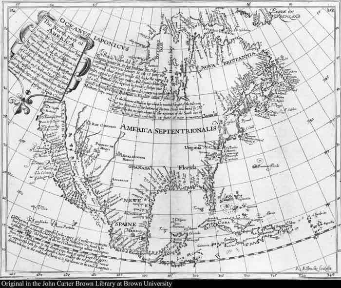
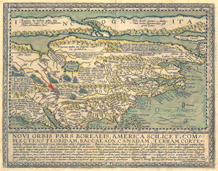
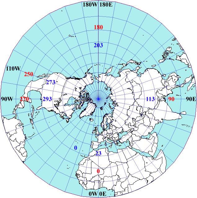
![[Big Grin]](biggrin.gif)
![[Cool]](cool.gif)
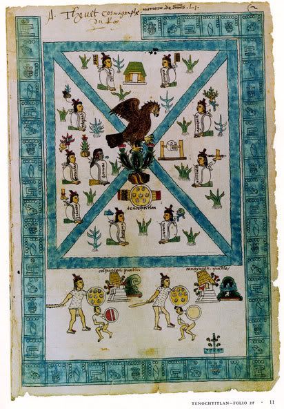
![[BadOne]](graemlins/headbash.gif)
![[Razz]](tongue.gif)
![[Wink]](wink.gif)