posted
(Note that the shores of the large lake on the 1569 Mercator map touch the arctic circle.)
Yes, but what about the lake that is southwest of the lake that you are speaking of? Unless I am mistaken and the article circle represents the circumference of the map.
posted
"...but the thrill of discovery drives me forward."
I knew that would happen, because I have been there before and have been there when it has taken over others. Like one of them said, "This is better than sex" (of course I type "sex", though that was not the word he used....) .
IP: Logged |
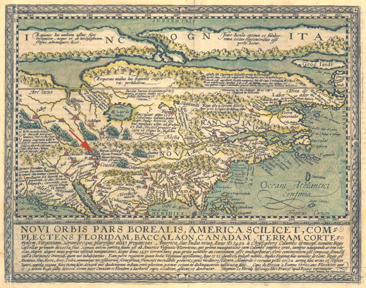
The 1589 map is very interesting because it does show two lakes, one of which is further southwest than the other. Closer examination reveals the southern lake is named "Lago de Conibaz". I have run across it on several maps and at first I believed it to the GSL. However, I found an earlier map that features both the GSL and a lake called "Lago de Conibaz". (I will try to provide an image here for you shortly).
Also, "Lago de Conibaz" is often featured showing an island in the center, while the ones I believe to be the GSL do not. In addition, with the exception of the 1589 Mercator map, "Lago de Conibaz" is always shown draining into the Arctic, while the lake I believe is the GSL, with one exception, is always shown draining into the Pacific via the Colorado. (The exception shows it draining via the Rio Grande into the Gulf of Mexico.)
I believe that "Lago de Conibaz" is an early representation of Winnipeg Lake, rather than the Great Salt Lake. However, because of the reasons I have cited, I haven't put the highest priority in pursuing this lead at the current time.
-------------------- One is never completely useless. One can always serve as a bad example.
IP: Logged |
The map that features both what I believe to be the GSL and "Lago de Conibaz" is dated 1593, by Cornelis de Jode. (I still seem to recall an earlier map, but I cannot find it in my archives.)
"Lago De Conibaz" is clearly visible, while the second, much smaller lake indicated by the red arrow, I believe is the GSL.
-------------------- One is never completely useless. One can always serve as a bad example.
IP: Logged |
quote:Originally posted by NaturalResources: ...I may be mistaken Peaser,
The map that features both what I believe to be the GSL and "Lago de Conibaz" is dated 1593, by Cornelis de Jode. (I still seem to recall an earlier map, but I cannot find it in my archives.)
"Lago De Conibaz" is clearly visible, while the second, much smaller lake indicated by the red arrow, I believe is the GSL.
just based on that map, I'd say GSL is north and east
-------------------- Nashoba Holba Chepulechi Adventures in microcapitalism...
IP: Logged |
posted
Tex, I agree. At first glance it does appear that the Great Salt Lake would be to the north and east of the location I have marked with the red arrow based on its relation to other features of the North American continent as shown on the 1593 De Jode map.
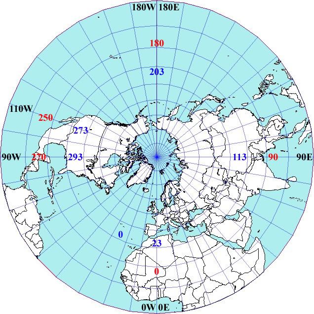
However, closer examination of the lat and lon of the lake reveals something that is either a complete coincidence, OR was intended by the cartographer of this map. The lat and lon of the lake I have shown is ~42N lat, ~263E lon. The modern lat and lon of the GSL is ~42N lat, ~112W lon.
When this map was made, cartographers often gave longitude only in degrees east of the prime meridian, so if we want to compare the two, we have to either convert the modern lat and lon of the GSL to the 1593 lat and lon used on the map, or the lat and lon of the lake on the 1593 map to modern lat and lon of the GSL.
In my example, I will convert the modern west lon of the GSL to degrees lon east, as is used in the 1593 map and compare it to the lake I have shown.
Prime Meridian = 360 Modern GSL lon = -112deg (or 112W) 360-112 = 248deg (or 248E)
Therefore the converted modern GSL Lat and Lon is 42N lat, 248E lon. If you compare this to the lat and lon of the lake featured on the 1593 map, (42N lat 263E lon) you will immediately notice that the latitude is exactly the same, while the longitude is off by only 15 degrees.
However, one more step must be taken before you can correctly convert modern lat and lon to the lat and lon used on the 1593 map...
Before the "Universal" Prime Meridian was established in Greenwich England in 1851, the location of the prime meridian varied from country to country and map to map. While the Dutch Cornelis De Jode 1593 map does not show where the prime meridian is, IMO it is reasonable to assume he used the Cape Verde Islands as his prime meridian, a common practice by Dutch mapmakers all the way up until the late 17th century.
The Cape Verde Islands have a modern lat and lon of ~15N lat, ~23W lon. This means that the prime meridian used in the 1593 map is 23 degrees west of the modern prime meridian in Greenwich. To correctly convert the modern lat and lon of the GSL you must also add 23 degrees to the longitude east because you are moving your prime meridian 23 degrees to the WEST compared to the modern prime meridian.
Modern GSL lon in degrees east before PM adjustment = 248 PM adjustment = 20
248+20 = 268
Thus, the converted modern lat and lon after adjustment for the Prime Meridian for the GSL is ~42N lat, ~268E lon, or only 5 degrees different from the lake featured on the 1593 map.
In addition, the fact that the latitude is dead on and the only "error" is in the longitude makes sense considering how much more difficult it was to deterimine longitude than latitude at that point in history.
To me, this suggests the lake shown on the 1593 map was intentionally placed there with full knowledge that a lake did indeed exist at that particular location.
BTW, I have been working on a graphic to present this information in visual form because I have found it can be very confusing trying to explain verbally. I hope I have done an adequate job here, and I'll try to post the graphic when I finish it.
NR.
-------------------- One is never completely useless. One can always serve as a bad example.
IP: Logged |
posted
I worked up a rough graphic for illustrative purposes only... The base map was obtain via google image search and the longitude was added by me. I do not intend to use this in my paper, though I will have something very similar.
The longitudes in BLACK text are based on Greenwich England as the prime meridian and shown using modern E/W longitude. The longitudes in RED text are based on Greenwich, England as the prime meridian and are shown in degrees east only. The longitudes in BLUE text are based on the Cape Verde Islands as the prime meridian, and are also shown in degrees east only.
-------------------- One is never completely useless. One can always serve as a bad example.
IP: Logged |
posted
Ok... I have a question maybe one of you can help me with.
If I wish to use images of maps in my paper, do I have to obtain permission from every source I use, or is a simple reference to the source of the map sufficient?
Also, say for example I were to use the graphic above in my paper. Do I have to obtain permission to use the "base map"? I am certian I could get around this by creating my own "base map" but this would be time consuming, and I don't really have the tools to do so.
TIA, NR.
-------------------- One is never completely useless. One can always serve as a bad example.
IP: Logged |
quote:Originally posted by NaturalResources: Ok... I have a question maybe one of you can help me with.
If I wish to use images of maps in my paper, do I have to obtain permission from every source I use, or is a simple reference to the source of the map sufficient?
Also, say for example I were to use the graphic above in my paper. Do I have to obtain permission to use the "base map"? I am certian I could get around this by creating my own "base map" but this would be time consuming, and I don't really have the tools to do so.
TIA, NR.
The short answer is...it depends on who owns the image. That's tougher to determine nowadays in the Internet Age, but well worth the time for a serious publishing endeavor...and crucial for academic publishing.
For example, legitimate book publishers pay professionals whose only job is to track down images, determine who owns the rights to them, and then to apply for permission to use said images. Oftentimes, they even credit these usually unsung heroes as "permissions editors" or some other like title.
For instance, within weeks of hiring on at a college textbook house, I was asked to look into a "little problem" for a new acquisitions editor whose stable included our art titles.
What I found was staggering: one freelance permissions editor was being denied permissions with OTHER PUBLISHERS simply because she had done work for us, and WE had not paid our bill...to the Rijksmuseum. In the other case, we had not paid the folks who manage Escher's estate.
In other words, two unpaid accounts threatened a *significant* portion of our arts titles: You can't do a serious "arts history" text without access to Escher, and of course going without the Dutch masters collected in the Rijks is unthinkable.
So, yeah, it can be serious stuff...problems that can be easily avoided for perhaps a small fee.
On the other hand, with data/images that old? You may find they are in the public domain and perfectly free for anyone to use...
-------------------- Nashoba Holba Chepulechi Adventures in microcapitalism...
IP: Logged |
I did some research on "permission editors" and most of what I read suggests that seeking "permissions" isn't something easily done by a novice, and is best left to the experts.
You mentioned problems could be avoided for "perhaps a small fee." Are we talking a few hundred dollars, or more?
-------------------- One is never completely useless. One can always serve as a bad example.
IP: Logged |
posted
That's good to hear Bdgee. At this point in time, my intent is to start with a paper for use in a "scholarly" journal, and then at some point, (assuming my theory isn't shot down completely), expand on it and move to book format.
While the sources of the images may not charge a fee for scholarly use, "permission" still needs to be APPLIED for correct? I am curious what I would have to pay to have someone do this for me.
-------------------- One is never completely useless. One can always serve as a bad example.
IP: Logged |
posted
Thanks Bdgee, I'll definately keep an eye out for that type of statement as I continue to research and collect evidence. I suppose this is something I don't have to deal with until my paper is "complete", but it's nice to know what I will be up against when I do reach that point.
-------------------- One is never completely useless. One can always serve as a bad example.
IP: Logged |
"According to the Copyright Act of 1976, codifying the common law doctrine of fair use, reproduction for noncommercial "purposes such as criticism, comments, teaching . . . scholarship, or research, is not an infringement of copyright." On this basis no scholar should be subject to charges for the right to reproduce visual material for scholarly purposes."
Though that says "visual" I think it holds equally for "printed".
IP: Logged |
Visual Materials: Visual materials that may be the source of an image include primary sources, such as original works of art, photographs, molds, architectural drawings, archival holdings, manuscripts, etc., and secondary sources, such as photographs, transparencies (including slides), microfilm, microfiche, film, videotape and disk, and journals.
Scholarly Publication: Scholarly publications are defined here as those publications that reproduce an image for an educational/cultural purpose and are directed to a limited educational/professional audience with, for books, a limited press run of less than 4,000 copies. A scholarly publication with a limited press run under this definition may be published by either a profit-making or a nonprofit-making or a nonprofit institution.
Hmmm... based on the link you sent me, it sounds like I am probably only going to have to worry about permissions if I decide to publish a book.
Thanks again for all your help Bdgee.
-------------------- One is never completely useless. One can always serve as a bad example.
IP: Logged |
posted
Yep. I've published a heap of quotes and such from other's works and never had to so much as check it out. Of course, I always reference and award credit when I can. I'm downright proud to be able to site someone's origination of an idea or technique. Believe me, there are enough ideas out to go around that it isn't necessary to claim other's.
IP: Logged |
While searching online, I often run across information relevant to my research that is available via the JSTOR Archives. However, the service is not free, and I am wondering if I should bother looking into paying for access.
TIA, NR.
-------------------- One is never completely useless. One can always serve as a bad example.
IP: Logged |
posted
I don't have access to JSTOR either, but often find it has something I need.
Generally by being creative and patient with search engines, I can find it elsewhere on the net.
In the few instances I couldn't. Fortunately I knew people that did have access (mostly people that have it via their work, like still active university professors) and they've sent a copy to me via email or regular mail.
If you don't know off hand anyone that has access, try popping onto the history department of the nearest college and ask for help. That would probably work. They will appreciate work being done for the simple reason of pure scholarship.
IP: Logged |
I have finally found someone with access to JSTOR... A co-worker is attending classes at PSU and is going to get the articles I need for my paper. Thanks for all you help with this issue Bdgee.
Also, I have made a breakthrough on some of my research, and I now have a few names to work with after suffering a major setback. However, information on some of the individuals of interest is scarce, so I am again asking for help.
I need any and all information/links/book titles etc. related to the following people.
1) Andre Thevet (1502-1590), French priest/explorer/author/cartographer 2) Sir Francis Drake (1540-1595) English explorer/cartographer/navigator 3) Jodocus Hondius (1563-1612) Dutch cartographer/artist 4) Michael Mercator (1567-1600) Dutch cartographer (Grandson of famous Gerard Mercator) 5) Guillaume Le Testum (1509-1573) French explorer/cartographer/navigator
I am particularly interested in information on Guillaume Le Testu, especially information regarding his 1573 raid on Panama with Sir Francis Drake.
TIA, NR.
-------------------- One is never completely useless. One can always serve as a bad example.
IP: Logged |
posted
I have focused my research over the last few weeks on the Frenchman Andre Thevet. Since he produced the earliest map featuring what I believe to be the GSL, it seemed appropriate. Unfortunately, Thevet was a known plagiarist, which is creating quite and obstacle in tracking down what sources he might have used to create his 1575 map.
However, my research seems to be paying off and I have uncovered a few very interesting facts. For example:
Andre Thevet is known to have had access to one of the rare Aztex Codices, namely the "Mendoza Codex". These codices were written by "pre-Columbian" and "colonial-era Aztecs". Written hundreds of years ago, even today these codices provide the best primary source for knowledge of Aztec culture and history.
The "Mendoza Codex" is a pictorial document, and includes Spanish annotations and commentary and was written in 1514. The codex was commissioned by the Vicory of New Spain (Modern-day Mexico), Antonio de Mendoza. It was completed in Mexico City, and was being shipped to Charles V, the king of Spain, when the ship it was on was seized by French privateers. The codex, along with the rest of the loot was sent to France. At some point after this, the codex ended up in the hands of Andre Thevet, who was French king Henry II's cosmographer. This fact is confirmed by Thevet's signature, which appears 5 times in the Mendoza codex, along with the date 1553.
As I have stated before, previous research has revealed that the most likely primary source for the knowledge of the GSL in the mid-1500's was through the Spanish, who were the only ones anywhere near the GLS at the time. However, the oldest maps I find featuring the GLS are French, followed by the Dutch then the English. All Spanish maps of the period (and even ones made prior to 1575) that I have seen feature the Colorado river, but not the GSL.
How could it be that knowledge of the GLS passed under the noses of the Spanish scholars yet ended up in the hands of the French? I believe the answer lies with the "stolen" Mendoza Codex. I speculate that through this codex, Andre Thevet gained the knowledge he needed to correctly place the GSL on his 1575 map of the Western Hemisphere.
It is an established fact that trade routes existed between Mesoamerican people and those that lived in what is now the southwestern United States prior to the arrival of Columbus (1492). Forged copper bells and parrot feathers have been discovered in Anasazi ruins dating back to the 1300's so it is not unreasonable to think that geographical knowledge, (particularly the locations of inhabited areas), was a part of those same trade routes.
The Aztecs, through the codices, claim they migrated from the north prior to Cortez's arrival and certainly could have had knowledge of the GSL. Even more intriguing, these same "legends" told in other Aztec codices claim the Aztecs were originally from a city on an island in a large lake. This city was known to the Aztecs as Aztlan, and it's description bears striking resemblance to the stories of Cibola told by early explorers of the American southwest including Marcos de Niza in 1539, one of the first recorded Europeans to set foot in the American southwest. These stories fueled the famous expedition by Coronado in 1542, searching for the mythical Cibola (Aztlan?) which he never found. Is it irony then that the Great Salt Lake would remain undiscovered as well until Dominguez and Escalante in 1776?
-------------------- One is never completely useless. One can always serve as a bad example.
IP: Logged |
posted
Great comment Glass. As best I can tell, there is no mention in anything I have read as to whether or not the lake surrounding the city of Aztlan is salty or not. This is important because as you said, large salt lakes are not very common and therefore it seems likely mention would have been made.
However, here is something I believe deserves consideration. I have read several places, (I don't have any references handy), that Tenochtitlan (the Aztec capitol) was supposed to be a "reproduction" of Aztlan. It just so happens that Tenochtitlan was built on an island in the middle of Lake Texcoco. The valley of Mexico has been a closed basin since at least the Late Pliocene, therefore making Lake Texcoco (now dried up) a salt lake! This is evidenced by the following translation of the Aztec "Boturini codex". It is taken from page 18 of a 21 page document, therefore it is taking place near the end of the Aztec journey from Aztlan to Tenochtitlan.
The location "Chapultepec", mentioned in the following translation, is a known archaeological site that rests on a mesa named "Grasshopper Hill" and overlooks Tenochtitlan and Lake Texcoco.
quote:In Year 9-Flint they settled in Chapultepec, Grasshopper Mountain, the rock that looks like an insect, the mountain that issues fresh water into the salty lake, the rock on which future Emperors would have their portraits carved. The people could see the whole lake from this place, could see canoes and caravans pass from city to city, could see the shining temples of all the gods, could see the colored palaces of militant kings, could take the measure of their neighbors' strengths and weaknesses, could see the islands that rose in the water. On one of these islands the heart of Copil, Huitzilopochtli's last godly enemy, had been cast, in the place on the rock, in the spot among the reeds where Quetzalcoatl had rested when he abandoned the Toltecs. The priests new the Promised City would rise in this place, would rise from Huitzilopochtli's victory, from their tests and their suffering, and from Quetzalcoatl's legacy. Those in charge of provisions saw the islands as places to catch fish and hunt birds, to pick berries and gather eggs and the edible plants remembered in legend from the lake in Aztlan where their journey began.
One other thing to consider. There are two commonly suggested translations of the name Aztlan. One is "place of egrets" and the other is "place of whiteness". Egrets or Herons can be found in both fresh and salt water, so this doesn't offer much help. However, the shores of a salt lake are most certainly a "place of whiteness", and, one could say the same applies to the Bonneville Salt Flats, which lie not far from the Great Salt Lake itself.
Perhaps this is all just concidence, perhaps not, but it's definately a "lead" I intend to investigate further.
-------------------- One is never completely useless. One can always serve as a bad example.
IP: Logged |
Antelope Island is a 75 square mile mile island of low mountains, grasslands, marshes, and sand dunes in the Great Salt Lake.
suppose the fresh water situation changed on antelope island? it also looks as tho the great slat lake could have had at least two other very large islands if the water levels were different, one in the bear river bay area and one near Burmester...
i can't help but notice that Aztlan is very similar to Atlantis in Greek Ἀτλαντὶς.
i wonder if there's any archeological sites?
-------------------- Don't envy the happiness of those who live in a fool's paradise.
IP: Logged |
According to historians, the Anasazi people seemed to disappear around the early 1300's which is roughly the same time the Aztecs claim to have left Aztlan. Also, historians suggest the main reason for the decline of the Anasazi was an extreme prolonged drought. This most certainly would have affected the supply of fresh water on Antelope Island and provided a reason for a massive migration to the south, where conditions were much better.
Another thing to consider, according to the Aztec creation myth, the Aztec people originally came forth from seven caves before they built Aztlan and there just so happen to be caves on some of the islands in the Great Salt Lake. I believe there is an archaeological site on Antelope island, and there are several more along the ancient shores of the Great Salt Lake, which prior to the drought in the 1300's was much higher than it is today (thus the lake waters prior to the drought would not have been as salty). However, I believe these sites date much earlier than the 14th century, though this is something I might look into further.
I haven't focused too much in this area, because the intent of my research is to discover where Andre Thevet got his information for his 1575 map, not to discover the location of Aztlan, Cibola or Atlantis. Also, I am a bit hesitant because the "history" of Aztlan, Cibola and Atlantis are shrouded in so much mystery, myth and fantasy. This is something I would like to avoid in my work because I don't want to be associated with the "lunatic fringe".
-------------------- One is never completely useless. One can always serve as a bad example.
IP: Logged |
quote:Originally posted by bdgee: I don't know about that salty question at all, but I do know I am seeing scholarship in progress. Good work, NR.
Thanks Bdgee. One thing I have noticed is that during the course of my research I am almost forced to become sort of an expert in anything I write about that is related to my research. I had no intention or interest in studying Aztec codices or the political/religious landscape of 16th century Europe when I started this project yet it has become necessary in order to complete my work. At times it seems overwhelming when I realize how little I know about various related subjects and the magnitude of the project I have undertaken starts to sink in... But, to stop now? Unthinkable.
-------------------- One is never completely useless. One can always serve as a bad example.
IP: Logged |
posted
It is with the realization of how much one doesn't know that a line is drawn beyond which one must become a researcher and scholar in order to find satisfaction. Most choose to stay on the other side of that line and never have the chance to feel the pure joy of discovery, not just discovery within the field of investigation, but discovery of ones real self and what that real self can do.
Something that those that choose to not take the challenge and remain on the other side of that line will never have is the sense of ultimate accomplishment and pride, not from monetary gain or anything similar or even from success in the area of study, but from the realization of one's potential and of one's self.
IP: Logged |
quote:Originally posted by bdgee: I don't know about that salty question at all, but I do know I am seeing scholarship in progress. Good work, NR.
Thanks Bdgee. One thing I have noticed is that during the course of my research I am almost forced to become sort of an expert in anything I write about that is related to my research. I had no intention or interest in studying Aztec codices or the political/religious landscape of 16th century Europe when I started this project yet it has become necessary in order to complete my work. At times it seems overwhelming when I realize how little I know about various related subjects and the magnitude of the project I have undertaken starts to sink in... But, to stop now? Unthinkable.
lol...that's what happened to me (with me, whatever) once I started trading.
Carry on! I'm enjoying following along.
best,
tex
-------------------- Nashoba Holba Chepulechi Adventures in microcapitalism...
IP: Logged |
quote:I don't want to be associated with the "lunatic fringe".
quote:what are you doing here then?
LOL, great... Wait till the "professionals" find out I started my work here on Allstocks...
BTW Glass,
I dunno how much interest you have on the subject, but here is a link to a brief but informative essay(?) on the history of the Salt Lake Basin from about ~8000 BC to ~1600 AD. It is from a book by Guy E. Gibbon, Kenneth M. Ames titled "Archaeology of Prehistoric Native America" on pages 146 & 147.


 UBBFriend: Email this page to someone!
 Printer-friendly view of this topic


![[Big Grin]](biggrin.gif)


