posted
California hit by a Hurricane? Impossible... NR is off his rocker.....
Not so fast...
According to this 2005 article by Jack Williams, USATODAY.com: ( Background: California's tropical storms http://www.usatoday.com/weather/whhcalif.htm ) between 1902 and 1997, California was hit by remnants of 38 tropical cyclones and although there are no records of an "official" hurricane hitting California, northern Baja California (aprx ~150 miles south-east of San Diego), has had several "confirmed" hits.
quote: August 1951: A hurricane moving north northwestward just off the west coast of Baja California moved northeastward into northern Baja California and dissipated. Moisture from this tropical cyclone resulted in rainfall of 2 to 5 inches in the southern mountains and deserts of southern California on the 27th through 29th. Many roads were washed out in the imperial valley...but otherwise no major damage occurred in southern California. This occurred during the El Niño of 1951-52.
quote:September 1976: North-northwestward moving Hurricane Kathleen made landfall in northern Baja California with the remnants moving into southern California. Hurricane Kathleen brought the southwest the highest sustained winds ever associated with an eastern Pacific tropical cyclone with sustained winds of 57 mph at Yuma on the 10th. Six to 12 inches of rainfall was observed in the central and southern mountains of southern California on the 10th and 11th. Most of Ocotillo, California was destroyed by flooding and three persons drowned. This occurred during the El Niño of 1976-77.
While it does seem unlikely that California could get hit by a hurricane, it should be noted that it IS possible, and if one looks at the closely at various other records it seems probable that California HAS been hit in the past, it just hasn't been "officially" acknowledged.
quote:"On October 2, 1858, estimated sustained hurricane force winds produced by a tropical cyclone located a short distance offshore were felt in San Diego," said Christopher Landsea, the co-author of a paper on the 1858 hurricane and a hurricane researcher at NOAA's Hurricane Research Division at the Atlantic Oceanographic and Meteorological Laboratory in Miami, Fla. "Extensive damage was done in the city and was described as the severest gale ever felt to that date, nor has it been matched or exceeded in severity since."
Coral evidence suggests the ocean was particularly warm that year and, according to a press release from NOAA, "Warmer waters and a conducive atmosphere allowed the hurricane to sustain Saffir-Simpson Hurricane Scale Category 1 intensity (wind speed of 72-95 mph) as far north as southern California. Available evidence suggests that the hurricane tracked just offshore from San Diego, without the eye coming inland, but close enough to produce damaging winds along the entire coast from San Diego to Long Beach."
The National Center for Atmospheric Research 180HR 500MB "GFS" Computer Model ( http://www.rap.ucar.edu/weather/model/displayMod.php?var=gfs_500_wnd&loop=1 ) shows a tropical wave forming on Wednesday the 29th that progresses into a hurricane. If the model is correct this will be named Hurricane Gil.
The model also shows a north-westerly track along the coast of Mexico with a final position at the end of the model on Sept 3rd of aprx. 600 miles south-west of San Diego. The 250MB model ( http://www.rap.ucar.edu/weather/model/displayMod.php?var=gfs_250_wnd&loop=1 ) suggests an eventual north-east and then easterly track towards California.
It is important to keep in mind however, that this model is both experimental, and less accurate as you go further ahead in time.
Most likely, Hurricane Gil will NOT even form where the model suggests, and even if it does, it probably won't track as the model suggests and this thread will sink down the memory hole, never to be seen again.
However, while it remains in the top few pages of All-Stocks Off-Topic let it serve as a reminder that we must always be on our toes, because the hits you don't see coming are the ones that hurt the most, and one never knows when mother nature is going to throw her next sucker punch.
NR.
-------------------- One is never completely useless. One can always serve as a bad example. Posts: 2430 | From: CA | Registered: Jun 2005
| IP: Logged |
posted
Here is the actual paper written by Michael Chenoweth and Christopher Landsee on the "1858 San Diego Hurricane" that is mentioned in the second article (PDF):
-------------------- One is never completely useless. One can always serve as a bad example. Posts: 2430 | From: CA | Registered: Jun 2005
| IP: Logged |
posted
You're a dyed in the wool weather buff aren't you NR?
Had an old girlfriend who was like that. Wanted to be a weather bunny but didn't have the follow through.
-------------------- No longer eligible for government service due to lack of tax issues. Posts: 5178 | From: Up North | Registered: Dec 2005
| IP: Logged |
posted
NR, i was ordering some stuff, and i noticed this place has survey eqpt too.. don't know if this stuff is any good or the prices are any good either, but, been doing biz there for 20 years, and have always been satisfied ...
quote:Originally posted by The Bigfoot: You're a dyed in the wool weather buff aren't you NR?
Had an old girlfriend who was like that. Wanted to be a weather bunny but didn't have the follow through.
Indeed Bigfoot, I am a weather buff among other things...
I would never make it as a "weather bunny", since I am male, but I suppose if I went back to school I could maybe get a gig as a crusty old weather parrot...
Honestly though, I'd rather be interpreting the charts and writing the forecasts than smiling for the camera while I read off a report written by someone at the NWS....
-------------------- One is never completely useless. One can always serve as a bad example. Posts: 2430 | From: CA | Registered: Jun 2005
| IP: Logged |
quote:Originally posted by glassman: NR, i was ordering some stuff, and i noticed this place has survey eqpt too.. don't know if this stuff is any good or the prices are any good either, but, been doing biz there for 20 years, and have always been satisfied ...
Thanks Glass. I'm not sure about the prices either. The Chief of Surveys at our company handles all the equipment orders, but I'll be sure to pass this along to him. I know he is always looking for good deals because crews are pretty rough on the equipment sometimes.....
-------------------- One is never completely useless. One can always serve as a bad example. Posts: 2430 | From: CA | Registered: Jun 2005
| IP: Logged |
quote:1. A LARGE AREA OF SHOWERS AND THUNDERSTORMS EXTENDS SEVERAL HUNDRED MILES SOUTHWESTWARD FROM THE COAST OF MEXICO BETWEEN ACAPULCO AND MANZANILLO. UPPER-LEVEL WINDS ARE MARGINALLY FAVORABLE FOR GRADUAL DEVELOPMENT OF THIS SYSTEM DURING THE NEXT COUPLE OF DAYS AS IT MOVES SLOWLY WEST-NORTHWESTWARD.
-------------------- One is never completely useless. One can always serve as a bad example. Posts: 2430 | From: CA | Registered: Jun 2005
| IP: Logged |
posted
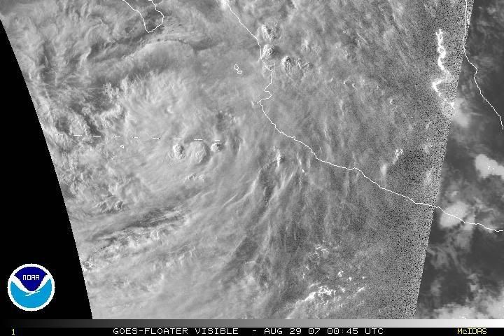
The latest GFS model run now shows a tropical storm making landfall near the southern tip of Baja California. While I am not at all surprised at the lack of consensus among each model run, I am impressed with the models ability to predict the development of this disturbance almost a day before it was visibly evident in satellite images.
Meanwhile, according to the latest tropical weather outlook for the East-Pacific from the NWS:
quote:1. A LARGE AREA OF SHOWERS AND THUNDERSTORMS EXTENDING FROM NEAR MANZANILLO MEXICO SOUTHWESTWARD INTO THE EASTERN PACIFIC OCEAN FOR SEVERAL HUNDRED MILES IS ASSOCIATED WITH AN ELONGATED AREA OF LOW PRESSURE. ALTHOUGH UPPER-LEVEL WINDS ARE ONLY MARGINALLY FAVORABLE FOR FURTHER DEVELOPMENT...THIS SYSTEM HAS THE POTENTIAL TO BECOME A TROPICAL DEPRESSION OVER THE NEXT COUPLE OF DAYS AS IT MOVES SLOWLY WEST-NORTHWESTWARD.
The latest images from GOES satellites of this area of "thunderstorms and showers" appear to show slight rotation and organization of this system within the last 8-10 hours. This is best viewed using the animated VISIBLE loop. ( http://www.ssd.noaa.gov/goes/flt/t6/loop-vis.html )
-------------------- One is never completely useless. One can always serve as a bad example. Posts: 2430 | From: CA | Registered: Jun 2005
| IP: Logged |
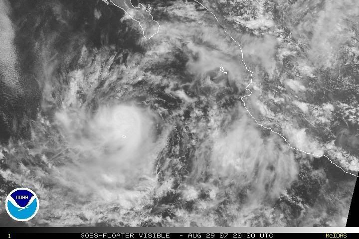
Maximum Sustained Winds: 40MPH Minimum Central Pressure: 999MB Located At: 19.7N 110.5W Movement: West-Northwest at 12MPH
quote:THE TROPICAL DEPRESSION HAS CONTINUED TO ORGANIZE DURING THE DAY. DEEP CONVECTION HAS BEEN QUITE INTENSE...THOUGH RECENTLY HAS WANED A BIT. MICROWAVE AND VISIBLE SATELLITE IMAGES SUGGEST THAT THE CENTER IS ON THE NORTHEASTERN SIDE OF THE THUNDERSTORM MASS. DVORAK INTENSITY ESTIMATES ARE 35 AND 30 KT FROM TAFB AND SAB RESPECTIVELY...BUT AMSU AND LOCAL OBJECTIVE ESTIMATES ARE HIGHER. THEREFORE...THE SYSTEM IS UPGRADED TO TROPICAL STORM GIL...THE SEVENTH STORM IN A RATHER QUIET EASTERN PACIFIC HURRICANE SEASON. A LITTLE MORE INTENSIFICATION IS POSSIBLE BEFORE THE STORM MOVES OVER COOLER WATERS TOMORROW. THE OFFICIAL FORECAST IS A BLEND OF THE SHIPS/GFDL/HWRF MODELS.
-------------------- One is never completely useless. One can always serve as a bad example. Posts: 2430 | From: CA | Registered: Jun 2005
| IP: Logged |
posted
I don't know about tropical storms, but were sure had a little rocker a few minutes ago. The dogs around here are sure upset.
Posts: 3875 | From: ca. | Registered: Jul 2005
| IP: Logged |
posted
Yesterday we went to a casino about a hour away from here and the temp was 114, they were having power outages to make things worse. I sure am glad i live near the beach, still a little toastly for here high 80's.
Posts: 3875 | From: ca. | Registered: Jul 2005
| IP: Logged |
Poor guy, it really isn't that far fetched that southern California could get hit by a hurricane. If you believe in global warming, then in theory, the odds are getting better every day.
-------------------- One is never completely useless. One can always serve as a bad example. Posts: 2430 | From: CA | Registered: Jun 2005
| IP: Logged |
posted
Now THAT would be pretty bad for SD. I think it would really shock them as they are not used to something like that.
-------------------- It isn't so much that liberals are ignorant. It's just that they know so many things that aren't so. Posts: 6949 | Registered: Apr 2004
| IP: Logged |


 UBBFriend: Email this page to someone!
 Printer-friendly view of this topic